
This page will continue previous discussions, which have looked at the creation of a 10 ft Scarp at Hemsby Gap in March 2023, the effect of steepening and lowering of the beach, and the influence of local sandbanks and tidal flows. News, content and photos on the page will consider ongoing developments concerning the severe erosion at Hemsby.

Loss
An extremely powerful storm surge has again caused severe erosion at Hemsby, leading to metres of dune loss and causing at least 1 resident to lose their home. The severe damage, compounds loss already experienced due to the demolition of about 5 properties on the Marrams before Christmas, with another 3 due to be demolished in the New Year.
Two storm surges the first on the evening of Thursday 1st January and the second early in the morning on the 2nd January, were over 1 metre in height and raised the tide at Lowestoft to just under 3.5 metres.
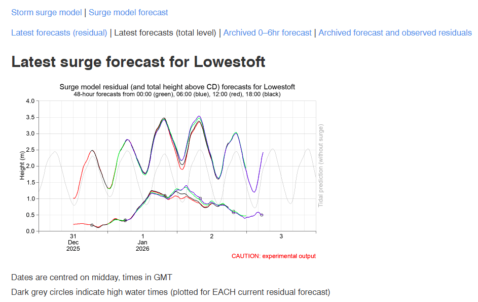
The second surge, early on 2nd January, was the largest. The tide height for Thursday 1st January 2026 at Winterton On Sea, next to Hemsby was 3.14 metres at 17:20 pm. The morning tide height for Friday 2nd January 2026 at Winterton On Sea was 3.39 metres at 5.34 am. The two surges forecast for just over a metre, would have raised the tide levels to over 4 metres.
Conditions that generated the two surges include a Low-Pressure system to the north of the UK, picked up by a section of the Jet Stream, which could have added to its potency. Surface Pressure Charts for midnight on Thursday 1st January and 12 pm on Thursday 1st January show a Low-Pressure system to the north of the UK, with tight isobars suggesting strong winds.
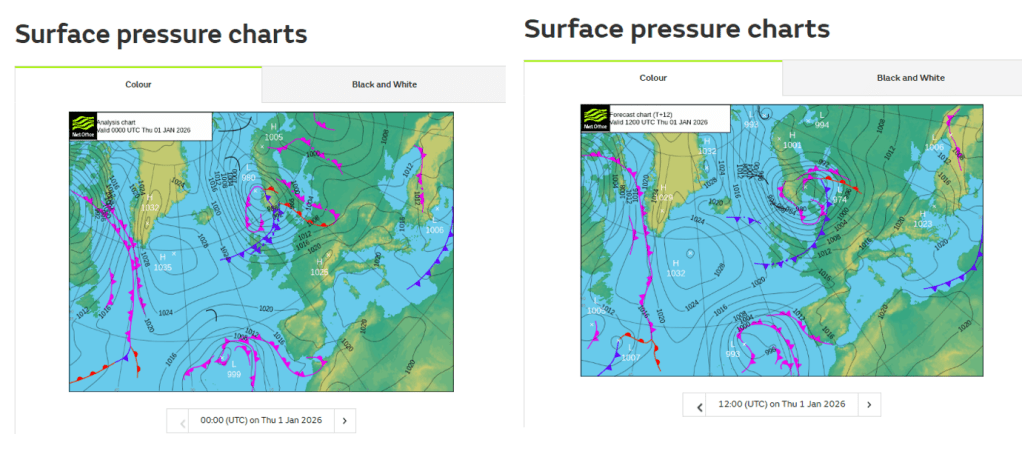
A warning for high wind speeds for the north-eastern area of Scotland was issued for 9 pm Wednesday 31st January – 9 am Thursday 1st January, New Years Day.
The high wind speeds were also predicted by the Shipping Forecast, with severe Gale Force 9 and Gale force 8 winds for North-East areas of the UK. Crucially, it is a change in wind direction which can also be a significant factor in generating a surge. The shipping forecast predicted a shift to North Westerly winds.
This switch was also recorded by the Happisburgh weather and wave gauge, with data showing an abrupt change to North Westerly winds at 10:30 pm on Thursday 1st January. A significant increase in wind speeds was also recorded at the same time, with up to 28.4-32.8 Gust speeds (Knotts) for a period of around 3 hours, 40 minutes. A wave height above Significant Wave Height of 2.94 was also recorded at Happisburgh at 2:30 am on Friday 2nd January.
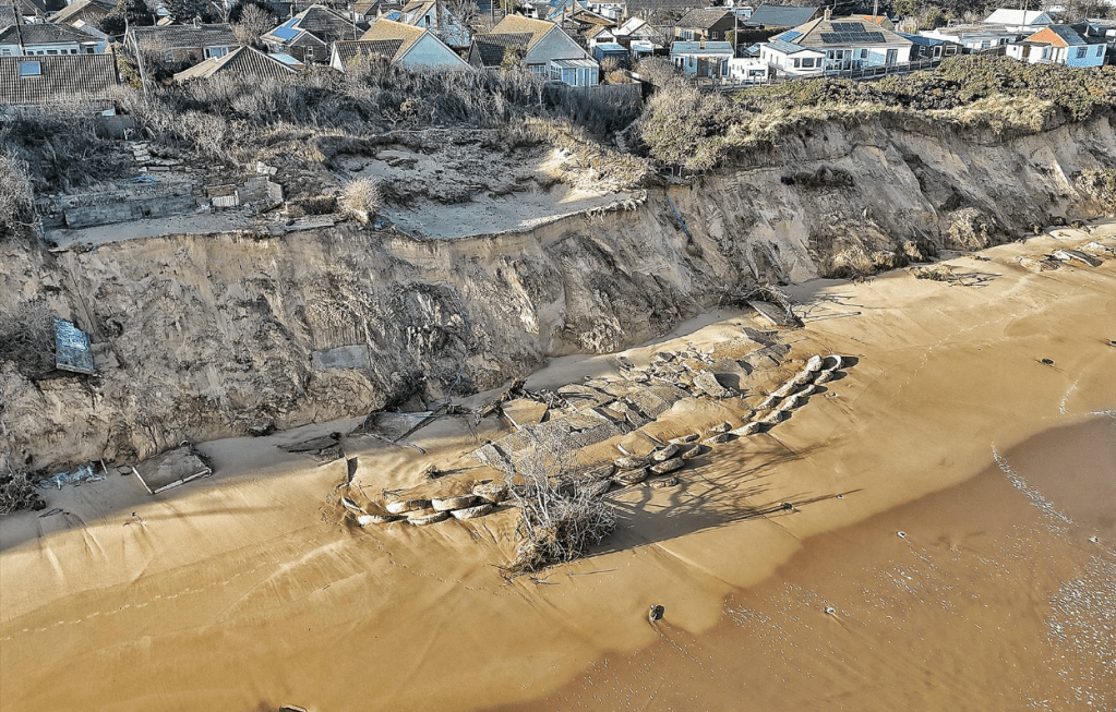
But equally, and much more immediate is the effect of the storm surge on the residents on The Marrams and the Hemsby coastline. The forceful conditions hit Hemsby with a savage blow that took away at least 4 metres of dune, stripping foundations away from a pensioner’s home, which means they could become homeless. A sizeable Scarp was created at the entrance to the beach, meaning access to the beach was closed off and the lifeboat unable to launch. Further loss of metres of dune at this location places the current position of Hemsby lifeboat station in even more jeopardy.
This the fourth extremely powerful surge of this nature, the three previous surges occurring on Friday 24th November 2023, Sunday 22nd/Monday 23rd December 2024, and Monday 17th November 2025. How should these very powerful, devasting surges and the loss they cause be viewed. The four surges have proved to be extremely strong, with each one re-writing, and removing the architecture, homes and people that make up very fabric of the Hemsby coastline. The forceful surges have also hit with little warning. For the latest surge, flood alerts and warnings for the Suffolk and Norfolk coast came out around early to mid-day on Thursday 1st January, but there was no flood alert or warning for Hemsby.
The immediate significance of the surges is the damage and the tragic loss of resident’s homes and the loss of a piece of the beautiful Hemsby coastline. But perhaps there is a wider question about the extreme strength of these surges. Is it the rapid change in wind direction and corresponding increase in wind speeds, or the association of the Low-Pressure system with a energised Jet Steam. Perhaps it is the energy levels in the surge that prove so devasting when they hit the coast. Equally, it could be the forceful weather conditions coupled with the Total Water Level that can cause so much damage.
If the surges are getting stronger, maybe there is a need to try and understand the energy levels that can raise the forceful sea so high. Additionally, if the loss that follows the surge, is also not considered, and what is being lost is not analysed and appreciated, how is a vulnerable coastline to prepare and adapt. To limit its losses and the destruction which can be so costly to manage.
Christmas Demolitions
The Community at Hemsby are suffering further heartbreak this week as demolitions are being carried out to some properties on The Marrams.
Thoughts on the Hemsby Page a little while ago, compared the terms, Demolition and Erosion. Coastal Erosion can describe the displacement of coastal lands and retreat of the shoreline, as well as the removal and transportation of eroded materials. Demolition can refer to actions to tear down or break into pieces, to destroy something.
In both descriptions of Coastal Erosion and Demolition, there are references to wearing away, destruction of a solid structure. But with both terms, there is an association that sediment might be deposited elsewhere, to build up a new beach or sand dune. Or a building or property might be demolished because a new Home is going to be built somewhere.
But with the demolitions this week at Hemsby the removal of structures does not mean the equivalent replacement elsewhere. The building up of a new solid base to call a Home. The forceful features that cause the erosion remain, with nothing to prevent further damaging retreat. While structures are removed, observers of the coast, people with lives and homes on The Marrams are lost with them.
But what happens when the structures are removed, is something also lost that could bind, not only a community together but also, metaphorically at least, bind a dune together. If a structure, a resident is loosened from their foundations, does this make a beach safe? Is a coastline made safer, simply by demolishing a property.
A coastline can evolve, can even, over time, build up a Ness or a sand bar to attenuate (lessen) the power of the waves. But if a coastline is fundamentally weakened, if the forces of powerful storm surges and high waves have broken the bones of the beach. A demolition that only removes, with nothing in its place to hold a dune or a community together. Could make a coastline vulnerable when rising seas and intense storms shake the foundations ever further inland.
Fragile Boundaries
A large storm surge that hit Hemsby early on Monday 17th November took a savage bite out of the dunes, with waves taking down parts of a fence and garden from a property in Fakes Road. The storm surge can be listed alongside equally powerful surges on Friday 24th November 2023, and Sunday 22nd December going into Monday 23rd December 2024.

The formation of storm surges describes how weather systems impose themselves on the surface of the sea. Low-pressure system linked to Storm Claudia on Friday 14th November, generated North-Easterly (NE) and Easterly winds for a period of four days. Wind waves can form when energy from the wind transfers into the body of the sea and moves through the transmission of the wave structure. How waves change and their size can be determined by wind speed, how long the wind blows on the surface of the sea and the distance over which the wind is blowing. This last factor is known as the wave fetch. Wind waves will progress in the direction that the wind that generated them is blowing, and NE waves were generated by prevailing winds.

The Wave and Weather Gauge at Happisburgh recorded a wave height of 3 metres on Friday 14th November. The Significant Wave Height (SWH) storm threshold at Happisburgh is 2.66 metres. The SWH is average height of the highest one-third of waves recorded at a particular point in time. The SWH storm threshold is the height at which waves could move significant amounts of beach material. Wind/Wave storms can persist for several days and can cause considerable damage on the coast; however, additional factors are required to generate a storm surge.
It is thought North Sea surges can be generated locally or can form as External surges due to meteorological conditions at the entrance to the North Sea in Scotland. Going back to weather conditions on Sunday 16th November, whilst wind gusts at Happisburgh on 16th of November were recorded as being around 15-21 mph, from a North Easterly and Easterly direction. The Shipping Forecast for areas such as Forties, North and South Utsire, Dogger, Fisher and German Bight forecast Severe Gale 9. With all sea states forecast to be rough or very rough, with some forecast to be high.
A Met Office chart shows surface pressure and weather systems at 12:00 am on Sunday 16th November, shows the presence of a low-pressure system to the north of the UK.

Additionally, most Shipping Forecast areas for the morning of Sunday 16th November predicted Northerly/backing North westerly winds. Some Shipping Forecast areas predicted North Easterly to Northerly. The Wave and Weather gauge at Happisburgh recorded a sharp change in wind direction at 3:20 pm on Sunday 16th November. Wind gust speeds increased, with peaks at times, of Gale Force 6 (25-31 mph) Gale Force 7 (32-38 mph) Gale Force 8 (39-46 mph).
The significance of the abrupt change in wind direction and the gradual increase in wind gust speed, is the change to Northerly winds would coincide with the flow of High Tide at Hemsby which was due at around 4:30 am on Monday 17th November. It is also thought that the tide and any surge on top of it take around 12 hours to travel from the North-East of Scotland to the entrance to the Thames. The way the earth rotates also dictates that water flowing down the North Sea is deflected to the right, which can mean sea water is piled up again North Sea coasts.
Storm surges can form when the effects of weather systems transmit deep into the body of the ocean, with sea water pushed in the direction of powerful winds. But when the forceful results push large volumes of sea water into the fragile boundary between the sea and the land, without warning, effects are felt deeply, shaking the foundations of dunes, homes and communities. Exploiting existing weaknesses and creating new ones. As in the absence of features to stand between the fragile boundary between land and the sea the ability of a community to withstand storm surges, risks crumbling like dunes hit repeatedly by the destructive power of the waves.

Surge Damage

Processes by which storm waves hit the dune face are described as the Collision Regime. Waves that can cause the most damage are described as Destructive waves. It is also said damage from powerful waves can transmit deep into the dune, causing cracks to appear metres from the edge of the dune.
A surge that hit the North Sea coast early in the morning on Monday 17th November brought all of these processes together with devastating results for Hemsby. A surge of nearly 1 m looks to have raised a Neap tide of 2.39 metres at Lowestoft to over 3 metres.

The surge follows a number of significant storm events with the effects of storms Benjamin and Claudia contributing to the attrition at Hemsby. One result of the storm surge early on the morning of Monday 17th November, saw a resident lose a large section of their access road, trapping them in their cliff top property.

Though a helpful neighbour has assisted to dig in a temporary access. A crack in the broken remains of their driveway, visible on 15th November 2025 could have been an unfortunate indicator of devastating loss to come.

As an indication of the volume of sediment lost and the extent of the retreat of the dune line, these photos taken two years apart, show how much has been lost in front of Lance Martin’s former home.


But while such processes are well documented, they could point to the establishment of long-term erosion systems that are said to leave a structural sign or autograph on a coastline. The physical features of such systems are known as Megacusp Embayments, the rhythmic erosion and deposition of sediment along a dune face. There are several wave systems that are thought to contribute to the formation of these features. But however such features are created, it could be said they could signify the introduction of a regular cycle of erosion.
Such recurring behaviours could source extra power from strong surges that hit the coast at Hemsby every year. Strengthened as they are by Northerly winds. Such erosion processes can be associated with the steady, continual retreat of a coastline. With the accumulation of sediment at the dune toe and a widening beach a temporary sign of stability.
The severe dune damage at Hemsby comes a week before a meeting is due to be held by the Great Yarmouth Borough Council Stakeholder Group to discuss erosion and options for Hemsby. Residents are hoping they can get a chance to discuss measures to stem the destructive pattern of erosion and halt the remorseless retreat of the dunes.

As with nothing to attenuate the power of the waves, and with beach levels lowering ever further, it is both the gradual attrition and the dramatic sudden erosion that drive damage deep into the dunes. Threatening to break and damage all they encounter on the cliff tops.
Loss on The Cliff Tops
Weather conditions associated with Storm Benjamin, named by Meteo France, created a particularly nasty low-pressure system over the UK. High waves and storm surges with gale force 8-10 winds blew over the North Sea for around 2-3 days. Slow moving low-pressure systems can be particularly damaging. Conditions can work to intensify energy levels and create storm surges that can persist for a number of days. With high waves hitting the dunes, resulting in severe erosion.

The stormy weather, follows an equally turbulent time for Hemsby. A report by Great Yarmouth Borough Council (GYBC) to investigate temporary remedial defence structures on Hemsby beach, recommended the sea defences be removed. Property owners fear this could make cliff top dwellings more vulnerable and GYBC have held conversations with residents about vacating their properties, so they can be demolished.
GYBC’s conversations with residents have occurred alongside the announcement of a scheme to offer residents a sum of money to assign planning rights to GYBC. So, residents can be given access to a piece of land with the idea they could build a new home on the land. But the sum of money offered is thought to be around £5000. It is likely this would not cover the financial loss of a home owned by a resident or provide resources to begin the task of building a new home.
For residents and business owners at Hemsby, it is an extremely worrying time, with the recent report and conversations, happening very suddenly. Followed quickly by dramatic storm conditions. Situations as severe as the erosion for which the coastline is known.
Residents and business owners fear an empty void, faced with potential loss of their home and rapid loss of dunes. With the newly created space holding concern, fear, instructions and demands, but no solutions. None that seem tangible and shaped, like the home and livelihood they thought they knew.
As the current traumatic situation at Hemsby, highlights two very pertinent questions, relevant to communities all along the coast. How to assist residents in a meaningful way and how to address the erosion. Particularly as events such as Storm Benjamin, look to be increasing in intensity, due to climate change. Adaption and resilience are discussed, but such words don’t replace a home.

Storms when they come can be sudden, powerful, unpredictable and dramatic. But preparation and planning for those on the edge, seems much less definite and accessible. If it is the case that there is no package or plan for assisting people who lose their home due to coastal erosion, or no programme with clear steps residents can identify and access, whatever their circumstances. Plots left empty on cliff-tops, symbolise more than loss, they signify the absence of an approach to foresee damage and alteration and take measures to avoid costly destruction.
It is not possible to know if flood defences in every location, would attenuate wave energy and prevent erosion. But simply casting residents out individually, with no additional measures to address resident’s situations in a meaningful way, risks effects on coastal communities hitting harder. If erosion is not managed with steps taken to lessen the effects, before forceful storm waves hit the dunes. Increasingly difficult and unpredictable demands could be placed on local and national resources.
On the cliff tops at Hemsby, past erosion episodes, with dune retreat and broken roads, act as signposts and lessons of what has occurred in the past. How the next chapter plays out could determine the significance of losses on the cliff tops for residents and coastal communities.
Friends of the Earth launch Challenge to European Court of Human Rights
The highest temperatures on record have been recorded for 1st May 2025 and an amplified Jet Stream has seen a Blocking Pattern of High Pressure, with associated North Easterly winds directing high waves towards Hemsby. Therefore, a recent announcement would seem timely that two men, ex-Hemsby resident Kevin Jordan and Doug Paulley, with Friends of the Earth as the third co-claimant, intend to launch a challenge to the European Court of Human Rights (ECHR) regarding the UKs Climate Change Adaption Plans.
The three co-claimants, Jordan, Paulley and Friends of The Earth claim the UK Government’s response to the climate crisis, fails to assess risks to marginalised groups or set out lawful ‘adaption objectives’ or assess risks to delivery of their plans.
Adaption to the damaging effects of climate change, could include implementing measures to equip communities with knowledge of likely effects and potential impacts, with monitoring systems in place to assess risks. With Planning systems and resources available and mechanisms in place to withstand or mitigate the worst effects. In addition to provision of compensation or equivalent accommodation for those who lose their homes or are made seriously ill due to the effects of Climate Change.
A more detailed outline of the need for Climate Change preparedness and adaptation measures for vulnerable coastal communities like Hemsby, has been submitted by Save Hemsby Coastline. The Written Evidence was provided in response to the Call for Evidence by the Environmental Audit Committee, concerning Flood Resilience in England. The Written Evidence seeks to highlight the particular needs of communities at risk of coastal erosion, as they can often seem overlooked by the wider agenda to address inland flooding.
One of the co-claimants in the challenge to the ECHR, Kevin Jordan, lost his home due to coastal erosion, because of a severe storm, in November 2023. Interviewed recently on ITV Anglia, Kevin said that he was part of the legal challenge, not just because of what happened to him, but because of all of the communities at risk of losing their homes, and livelihoods due to damage caused by coastal erosion.
For residents still living on The Marrams, close to the edge at Hemsby, they seem to be in a position as simple observers, as chunks of the driveway to their property, fall on to the beach, as the damage of pounding waves, transmits into the dunes.

The vulnerability of residents of coastal communities and those at risk of the damaging effects of climate change, have been highlighted by the Climate Change Committee, a statutory body set up under the Climate Change Act 2008.
As weather systems made more intense and unpredictable due to climate change bring conditions, communities are unfamiliar and unprepared to deal with. Simply hoping that the sun will continue to shine, will not help sufferers like Doug Paulley, whose health is badly affected by soaring temperatures. Just like wishing for light winds, will not solve the structural weaknesses on beaches like Hemsby, that make fragile coastal locations at extreme risk due to intense storms due to climate change.
Surges of the North Sea

A Surge is forecast for the North Sea for the evening of Sunday 30th March 2025. The forecast at Lowestoft is for a surge of around 1 metre, while a number of flood warnings and alerts warn of raised sea levels above tidal heights of around 0.5-0.6 metres.
A surge is an elevated body of water increased in height by combined forces of low pressure and winds acting on the surface of the sea. Low Pressure systems have been active for several days in the seas around Scotland and the North-West of the United Kingdom.

Surges of this size can be particularly concerning when they coincide with High Spring Tides, as sea levels are already heightened, and flow will be quicker.

Flood warnings and alerts have been issued for the Norfolk and Suffolk coasts, with concern also for vulnerable coastal communities such as Hemsby, a location already suffering the effects of erosion from winter storms. With erosion features such as Megacusp Embayments noticeable on the faces of the dunes, south of Hemsby Gap.

Erosion features such as Megacusp Emabyments suggest the presence of rhythmic rapid flows of forceful wave action and/or rip currents, that in turn erode an embayment and deposit sediment on the edges or ‘horns’ of the Megacusp Embayments. Erosion patterns such as these cut into the dune and facilitate the speedy removal of sediment as well as hint at the height of the waves as they display signs sea water reached the top of the dune.
Channels cut into sand banks on Hemsby Beach, suggest the presence of rip currents, which cut through sand to facilitate the hasty removal of sand offshore.

Winds of around 30-40 knots were recorded at Happisburgh just before mid-day on Sunday 30th March 2025. It remains to be seen how these winds will have transmitted their energy to the surface of the sea. As there is a lag between weather conditions and surge generation. As the forces of the weather work to form the infamous surges of the North Sea.

The question is not what you look at but what you see
Henry David Thoreau – I to myself, August 1851. Quote appeared in Book Wilding by Isabella Tree.
Easterly winds during the half of February 2025, have contributed to further erosion at Hemsby. Even though tides were low, strong onshore winds increased wave heights, driving higher sea levels towards the coast.

A small Scarp was created at Hemsby Gap and a low-level scarp appeared for a time, on the section of beach between Hemsby Gap and the rock armour below the Southern Marrams.

Easterly wind waves also stripped more sand from the beach and dunes, with the section of dune near the Lifeboat station, now look extremely vulnerable.

Agitated sea states can be like a river in full spate, with waves exhibiting a powerful forward momentum with action focused on the beach.

To briefly consider the processes at work, waves that form through wind acting on the surface of the sea, can be seen as carriers and transmitters of energy with the height of a wave a likely indicator of the energy it contains. The amount of energy retained by a wave depends on whether it encounters resistance with the seabed, if a steepening profile causes it to crash, or energy transmits to nearby waves or currents.

The relationship between wave energy and sediment transport could be summed up by considering the following four points. Firstly, whether waves are thought to be Constructive, which means they possess a significant Swash that could enable a flow of sediment up the beach. Or Destructive which means the possess a significant Backwash that could remove sediment from the beach.
Secondly, Constructive and Destructive wave can apply to waves grouped into four wave types (Galvin, 1972). Constructive waves can describe the following wave types; Surging, low calm waves, whose character can change if they wash up a beach with a steep slope. Collapsing waves that lessen as they travel towards the beach and Spilling waves that are concise, elevated and generate foaming bubbles as they crash.

While Destructive waves can describe a type known as Plunging waves with a vertical front which curls and crashes, generating little swash but a powerful backwash.
Thirdly, the point at which waves enter shallow water influence wave behaviour and the likelihood of sediment transport. In shallow water waves can lose speed and their wavelength shorten. If the wave encounters minimum friction with the seabed, energy could be retained, and the wave height increase, to compensate for loss of wavelength. A process known as shoaling.
Additionally, if a wave encounters a partial barrier, elevation shifts across the length of the wave causing it to curve round the rear of the barrier, a process is known as diffraction. Shoaling and diffraction can cause complicated wave behaviours when they encounter sandbanks, channels and shallow areas of water. With constant changes likely to wave elevation and position.
The question of how to manage these divergent, complex systems and their effect on the coast, has been discussed in a recent study to look at coastal erosion of sand dunes in Cornwall. The academic paper compared use of the Bruun rule, which states that beach and sand dunes under Sea Level Rise could shift inland and increase in height. With sediment removed from the dunes, accumulating in the near shore to maintain the steady profile of the beach.
When applying the Bruun Rule to dune erosion, the study found a blanket assessment of an entire dune system, might not account for specific examples of dune erosion or accretion. It also assumes a constant sediment supply, which isn’t always the case. Instead, it is suggested an initial whole coastline assessment, be followed up with models, adapted to operate and account for beach and dune conditions in erosion risk areas, to compile local specific information about a coastline.
It is clearly necessary for coastal planners to produce forecasts, with a standard 50–100-year approach often used. With predictions of future encroachment of the sea able to determine action needed on the land. With guidance of estimates of likely power and energy levels in the sea, with assessments of increased sea power in terms of erosion and loss. Based on these assessments, mechanisms could be put in place to mitigate and reduce erosion at vulnerable locations.
But both approaches face the dilemma of whether it is possible and effective to deal with coastal change mainly through managing the land. Particularly as sea states are both increasingly determined and made more powerful by weather systems at the other side of the world. Sea and land can clearly alter with presumptions of erosion boundaries shifting dramatically.

Because perhaps, when considering coastal assessments and what to look at and what to see it could be a question of interpreting the signs inscribed into a coastline or written in waves elevated by storms. As Sea Level Rise appears as measurements in academic papers, communities on the coast feel they live from tide to storm. Isolated buffers, like rocky outposts, looking at dune and cliff retreat biting ever further inland. As they see and try and interpret the complex strengthening interaction between sediment, energy and the sea.
Sharp Lines of Erosion

Storm damage has caused severe erosion at Hemsby with the ending of the old year and the start of the new brought in by a series of surges and strong winds that cut deep into the dunes and Access Ramp at Hemsby Gap.
It is estimated that 44 ft, (13 + metres) of sand was lost from Hemsby Gap and along the section of dunes fronting the Southern Marams between the Gap and the Rock Shield.

With the collapse of another two sections of Access Road, making it almost impossible to walk along The Marrams from Beach Road.

During exceptionally stormy weather on New Years Eve going into New Years Day, Gale Force Winds of 8-9 on the Beaufort Scale were recorded at Happisburgh. Storm Surges forecast at Lowestoft measuring just over or under 0.5 metres, for 1st, 2nd and 3rd January 2025. With the potential to raise the level of High Water at Lowestoft to either just below or just up to 3 metres.
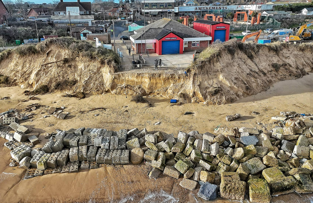
A 12 ft (+3 metres) Scarp was created at Hemsby Gap with the distance between the Scarp and the Rocks an indication of how much sand was lost at Hemsby Gap.

The Hemsby Independent Lifeboat service was temporarily taken out of service, but on 11th January 2025, Hemsby Independent Lifeboat crew again reinstated the Access Ramp to Hemsby Beach.

The Hemsby Independent Lifeboat Station is now around 70 metres, (230 feet) from beach. With further erosion to the Car Park north of Hemsby Gap concerns are growing for the long-term viability of the Lifeboat Station.
One of the most noticeable elements in videos taken of the storms is the large forceful run-up of surge water against the dunes at Hemsby Gap.
Should the duration of forceful waves and winds continue for a considerable length of time, conditions could establish a storm regime for wave run-up, dune impact and swift sediment transport.
Particularly as a channel has been observed running North to South past Hemsby Gap.

It has been thought a channel can be seen sometimes running down from Winterton Ness. The presence of a channel running along the beach could focus high velocity flows towards Hemsby Gap and the dunes immediately to the South. Or it could facilitate the rapid transport of sediment offshore, through the Backwash of retreating storm waves.
A series of exceptionally strong intense storms occurred during December 2024, going into January 2025, with unusually strong winds forecast for the East Anglia Coast. Such conditions can be made more forceful if they are made more intense by warmer ocean temperatures over the Pacific where these storms can form. Particularly if they get picked up by the Jet Stream, which can be more powerful at certain times of the year due to temperature differences in the area separating the Poles and the Equator.
International weather systems can generate deep Low-Pressure systems that can act to swell sea levels up against North Sea coasts. Such conditions have seen metres of sand and road removed from Hemsby December going into January

Erosion has cut new lines into the dunes, jagged lines marking the edge of access routes now deemed unsafe, lines indicating the retreat of the beach ever closer to the Lifeboat Station.
But the complex processes of storm waves and erosion are not straightforward or clear-cut, and the outcomes of damage, displacement and loss are hard to quantify and rectify once they have occurred.
The erosion seems to be creeping ever further inland, with reports of gardens around Fakes Road beginning to crumble as the dunes retreat. With the view that Fakes Road has become the new front line. As a new year begins it might become increasingly difficult to define the line in the sand that the forces of erosion should not cross.
Tipping Point

It’s the season of giving but it would seem the weather and the sea didn’t get the memo with the cumulative effects of strong winds producing two sizeable storm surges on 19th and 23rd December, with metres of dunes lost at Hemsby. A period of extremely strong Atlantic storms produced very strong winds in Scotland, and this pushed storm water down the North Sea,

At Happisburgh strong winds were recorded of around 31-47 Gust Speeds (Knots) for a period of around 12 hours on Sunday 22nd December going into Monday 23rd December. With a significant wave height of around 3.11 metres. The storm alert threshold for Happisburgh is 2.66 metres. Unusually, a Northwesterly Severe Gale force nine wind was predicted for a time by the Shipping Forecast for the area of Suffolk, Norfolk and the Thames, overnight on the 22nd and 23rd December. The force of the wind and waves combined to produce a surge of around 1 metre, forecast to push a Neap tide up to around 3.5 metres at Lowestoft.

The effect of the storm surge caused a section of a New Road to collapse, which has placed properties at risk on the Southern Marrams at Hemsby.

In addition, a Memorial Bench at Hemsby Gap had to be moved as it was in danger of falling into the sea.

The discussion below on the Hemsby Page discussed the usefulness of considering a Destruction Limit – the point at which the scale of storm conditions surpass the ability to withstand erosion and threaten the foundations of a coastal community. With cliff retreat pushing ever further inland, it could be appropriate to raise the question of a tipping point. As surging waves tear down chunks of cliff and the boundary crumbles away between what can be managed and what is unsustainable to lose.
Appeal to Climate Change Adaption Plans

Fears of potential storm damage from Storm Darragh have coincided with the announcement by Friends of The Earth, of their intention to appeal the outcome of the Judicial Review that the Governments plans for Adaption for Climate Change are lawful. The original Judicial Review and Appeal features two co-defendants, one of whom is Kevin Jordan, an ex-resident of Hemsby, who lost his home as a result of the 24th November 2023 Storm Surge.

8th December 2024 marks a year since Kevin had to move out of his home, due it being deemed to close to the edge after a 1+m storm surge and Northerly winds, caused 200 metres of Access Road to collapse on the Southern Marrams at Hemsby.
To consider the question of adaption in the face of increasingly powerful storms under Climate Change, it could be useful to consider concepts such as a damage threshold, or a destruction limit. This concept could be summed up in the following way. The level at which storm conditions outstrip coastal communities and landscape’s ability to adequately respond to unpredictable, punches in wind and sea energy.
In terms of a beach, the level and type of erosion experienced by a coastline is assessed by studying Significant Wave Heights, Surge levels and predicted tides. In order to examine where high-energy waves arrive at a beach. Whether they simply hit the swash zone, (the area where waves run up and down the beach), or hit the toe or frontage of the dune (the collision zone), eroding or causing failure. In addition to wind speeds and low-pressure levels. It is also thought propulsion in wave run-up is a better measure of the likely impact of wave energy along with wind direction and duration of storm weather.
Destruction levels at Hemsby due to storm Darragh have so far seen around 3 metres of sand lost from Hemsby Gap. As a result of high winds and low pressure systems, a surge of over 1 m was forecast for around midnight on Saturday 7th December/Sunday 8th December, at Hemsby. Storm conditions have seen several low-pressure systems transfer their potent energy into the North Sea with Gale Force 8-10 winds for a number of days, albeit with differing wind directions.

Fears remain about the High Tide due at 11:57 on Sunday 8th of December.
Applying these observations to the question of Adaption, one feature of recent storms in 2024, has been the power and the sharp spikes in energy, causing rapid increases in wave height and wind gusts. Like the sudden peak on September 27th, 2024, when during a storm, wind gusts suddenly rose to 47.1 Gust speed knots with Low Pressure measured at 991 mb with a wave height of around 2.83 metres. This rapid spike took the Happisburgh Wave Buoy out of service, with several weeks before it could resume weather sea state measurements.
Intense storms once they are in full force, take on a power, direction and momentum of their own. With Storm Darragh arriving sooner than predicted, with Red Alert danger to life severe wind warnings communicated to phones as the storm was already raging. In many cases, in locations covered by Yellow Wind Warnings for days previously.
To determine the destruction limit for a coastline or community, would seem to require a change in approach, to examine the new anatomy of these recent powerful storms. To adapt coastlines and communities to foresee and provide for the needs of people and beach. To secure the needs of those least able to respond to sudden rapid destabilisation if preventative, adaptation measures are not implemented.
As people and houses are not quite as resilient as wave buoys, and don’t repair as easily or respond well to the forces of storm energy if they transmit through dunes, to shake the foundations of homes and brick dwellings. Should adaption plans not be present to mitigate, harness and lessen the ferocity of storms enhanced with increasing strength due to climate change
Severe Storms threaten Hemsby
It is less than 2 weeks since the anniversary of the 24th November 2023 that saw a surge of around a metre take down 200 metres of Access Road, on the Southern Marrams at Hemsby.
Now in a very real reminder of the destruction on 24th November, High Winds and a Surge forecast, once again threaten to destabilise the remaining dunes and homes at Hemsby.
The National Tidal Sea Level Facility, and the National Oceanography Centre, University of Liverpool, forecasting service, publishes forecasts for certain locations round the coast of the UK. The service produces a forecast for Lowestoft on the Suffolk Coast, in the United Kingdom. The forecast for Lowestoft for 6th December 2024, suggests a surge of 1-1.5 metres, which could push up a Neap Tide to just shy of 3.5 metres.

However, it is not just the size of the surge that is significant, but the weather conditions that generated it that can work on the surface of the sea. Two powerful Low Pressure systems are currently affecting the UK, with very strong winds.

The Shipping Forecast for 6pm Thursday 5th December – Friday 6th December forecasts winds of around Gale Force 8-10 over the evening of 5th/6th December. It is suggested on the Beaufort Scale that for winds upwards of Gale Force 8, can generate significant high waves.
The Wave and Wind forecast for Hemsby suggests wave heights could reach around 2-2.5 m with winds around 50-55/60 kw/h.

The Low-Pressure systems which have originated from the Atlantic are particularly intense, as they seem to have a pattern of absorbing energy from warmer ocean temperatures, heightening their potency. In addition to being swept up by a very powerful Jet Stream, which is currently projected to have speeds of around 250 miles an hour.
Low pressure acts to raise the surface of the sea, and the weather systems currently operating over the UK have deepened pressure systems quite rapidly. This can elevate the strength of a storm and increase the force of energy in waves and currents which constantly form and rework channels and sandbanks on coastlines like Hemsby.
The weather systems have raised fears of a repeat of the destruction wreaked on Hemsby on 24th November 2023. Members of the Lifeboat crew have begun to warn and assist residents whose properties are close to the edge at Hemby. The Lifeboat crew are grateful for a local business Richardson for allowing an open rest room for community members affected by the storms.
Residents have been warned to prepare for the worst as the new weather systems pose are hard to predict and threaten to further destabilise and damage this fragile coastline.
Climate Change Adaption

On Friday 25th October 2024, the High Court, in London, United Kingdom, ruled the Government’s Climate Adaption Plan, (NA3) was considered to be lawful. The ruling was brought in response to a Judicial Review brought by Friends of The Earth (FOE) and two co-claimants, Kevin Jordan, an ex-resident of Hemsby, who used to live on The Marrams, and Doug Paulley. Mr Paulley is a disabled man who suffers serious health conditions in times of extreme heat.
The Judicial Review brought by FOE, and the two co-claimants, sought to make the case that the previous UK Governments Climate Adaption Plan, (NA3), was unlawful because it lacked provisions to enable UK residents, like Kevin Jordan and Doug Paulley, to manage and cope with the extreme effects of climate change. FOE, and co-claimants are now considering whether to appeal the High Courts ruling.
In considering perceptions of preparedness for extreme weather events., communities in coastal areas subject to severe and gradual erosion sometimes perceive themselves to be mere observers. As they observe cliffs crumble and fail, beaches stripped of sediment face increasing damage and intense rainfall cause cliffs to crack and fall in dramatic fashion.

However, community concern, might appear on a graph to be larger, than the available policy or accessible resources needed. To both grapple with erosion and enable communities to adapt in ways that sustain living arrangements and include vulnerable groups.
It is said beaches and coastlines change all the time, and analysis of these processes, to be useful, must evolve and learn to keep up with beach and sea behaviours, Perhaps, policy such as Climate Adaption Plans also need to grow to ascertain the gradual and sudden nature of coastal erosion and the effects of high seas. A map of the recent, frequent flood alerts on the Norfolk Broads, indicates the potential challenges as intense rainfall and surges can raise water levels, preventing water leaving the Broads. In addition to further damaging weakened coastal locations.

Placing the coastal location of Hesmby, where co-claimant Kevin Jordan used to live, in the wider geographical location of the coast and the Broads, could suggest a policy move beyond simply assessing need to formation of measures necessary to manage challenges. As it could be a question, of how is need in such locations quantified, in the face of climate change, can it be economically assessed in a predictable manner. Are measures required, to be determined by comprehensive, thorough adaptation plans, drawn up with time in hand. Or forced by High Water and rough seas that could cause conditions potentially more costly than the adaption measures that could have mitigated and enabled adaption to such circumstances.
Mind the Gap
In an early casualty of Winter storms, the sand ramp used by the Lifeboat crew at Hemsby to launch their lifeboat to answer emergency calls has suffered serious erosion. A 10-15 ft (around 3-4 metres) Scarp (drop) has formed at Hemsby Gap. The erosion occurred during a period of intense strong winds that began on Monday 30th September and continued until at least Wednesday 2nd October 2024.

A Low-Pressure system remained stationed over the North Sea, with the Shipping Forecast giving notice of winds up to gale force eight, from Monday 30th September to at least 6 pm on Tuesday 1st October. Met Office forecasts for Hemsby beach predicted wind speeds below 20 miles per hour. However, wind gusts were forecast to reach a maximum of 47 mph, with gusts of around 30/40 mph more widely predicted. Wind gusts decreased to 26/27 mph towards the end of Tuesday 1st October, before rising to 38 mph by mid-day on Wednesday 2nd October with wind speeds of 36/ 35 mph continuing for much of the day.
Wind direction can influence the effects of strong winds on the surface of the sea. While South-Easterly winds were forecast for Monday 30th September moving to West/South-west. A change from Westerly to North-West winds on the afternoon of Tuesday 1st October, could have begun the process of pushing sea water down the North Sea coast. A situation exacerbated further when winds began to blow from the North-East on Wednesday 2nd October.
Conditions, further complicated with the addition of a Spring high tide of 3 metres due at Hemsby at 07:15 am on Wednesday 2nd October. A tide made more forceful by the duration of strong winds acting on the surface of the sea.

The Gap at Hemsby is maintained to normally allow the Lifeboat to operate and for members of the public to have access to the beach. But it is in the front line when powerful sea states hit Hemsby Beach. With the weather and forceful wave action, combining to cut in to the sand causing the rapid removal of sand causing the Scarp to form.

Intense windstorms are common in the North Sea, at any time of year, but can be more powerful during the winter season. But high velocity waves, whipped up by winds and raised by low pressure, know only force when they hit fragile coastlines. Erosive elements that function only to take away, to remove what they crash up against.

Because perhaps what is missing is the gap between complex, forceful conditions at sea and features capable of answering the powerful forces of wind and waves.
Hemsby Visit – a Year Later
The following discussion will consider two visits to Hemsby, conducted almost a year apart. The first visit was on 17th September 2023 and the latest visit was on 7th September 2024.
Visiting Hemsby a year on, is to observe a dramatic change, to experience even more an absence of stability. Homes remain but without a road, an empty void where connection used to be.

But perhaps being up on the Marrams, provides a good vantage point to assess the resilience of a coastline.

Because rather than focus on what has been lost, perhaps it is more useful to ask what the landscape trying to tell you. Edges of roads and erosion features act like breadcrumbs, joining the dots of storms, surges, the accumulated attrition of wave action that has caused much damage over the years.
Loss of roads and metres of dune have occurred before in storms in 2013 and 2018. The landscape a year ago displayed signs of earlier wars with the sea. Therefore, is it not just a continuation of what has occurred before.

Processes of erosion past and present can be assessed to consider how dunes are eroded, transmitting failure to deep inside the land above. But to consider a year on, whether a coastline can independently repair and reach to a new equilibrium, is hard to assess when the intensity and power of waves, currents and swells are not easily quantified or measured over time.

The scale of what Hemsby has lost, could suggest a thought to move beyond numerical estimates of metres lost per year and begin the difficult task of approximating the level of energy arriving at the coast in the increasingly frequent storms.

Photos of Hemsby go out of date quite quickly, but the signs of erosion and broken features like the term Palimpsest remain perhaps as question marks. To ask whether a coastline and a community can continue to act as shock absorbers, to the pounding waves, swells and currents that continue to both build up areas, and wear away dunes and infrastructure and people.

A new sandbar looks like it is starting to form, reaching down north of Hemsby Gap. But whether it attenuates (lessens) the power of the waves or drives high velocities of sea water towards vulnerable dunes, will be determined by waves and storms that seem to have the last say on this coastline.

Children’s Parliament hold Emergency Cobra meeting at Hemsby

On Saturday 14th September, the Sir David Amess UK Children’s Parliament for primary school children held an emergency Cobra meeting to address coastal erosion at Hemsby.

The meetings was held at The Dunes at Lodge Park Homes, with the aim to recreate ‘Westminster’ on the dunes. A LEGO recreation of the Coastal erosion problem by ICONIC, was available to view at House 29 (Cedar Property), The Dunes by Lodge Park Homes, King’s Way, Hemsby, Great Yarmouth, NR29 4JT.

The Child Prime Minister Clark Dearson, 11, is quoted as saying that “The erosion situation in Hemsby is urgent: children are being affected, and homes are being lost.”
The dunes at Hemsby are increasingly vulnerable, with signs warning of Crumbling Cliffs, where the access road along The Marrams used to be.

With homes close to the edge, under threat from Northerly winds and high waves, which can cut sand and undermine the dunes, making foundations on The Marrams increasingly vulnerable.

Such vulnerabilities were food for thought for young child parliamentarians, as they considered Coastal Erosion concerns of current residents on The Marrams. As well as those who may find themselves dealing with similar issues in the future.
Sunny Beach Days – Resilient Coastlines
Recently a Judicial Review Hearing brought by Friends of the Earth with two disabled co-claimants, ex-Hemsby resident Kevin Jordan and activist Doug Paulley highlighted the robustness and adequacy of Government plans for Adaption. In relation to forecast extreme weather due to climate change. Concern focused particularly on the needs of marginalised groups who could suffer from the effects of Extreme Heat or severe Coastal Erosion.

Hemsby’s concerns about Sea Defences and experiences of acute damage and loss of homes were to the forefront during the 2-day Hearing at the Royal Court of Justice. Such concerns are never far away from the minds of Hemsby residents, even though Hemsby has been fortunate recently to enjoy some time in the sun, with sand accreting (accumulating) on the beach.

With sand building up on the beach as well as vegetation growing on the dunes, this offers the opportunity to consider processes that enable sand to flow onto a beach. A consideration of these matters offers an opportunity to consider the resilient properties of a coastline. In relation to the restoration of a wide beach, sand accumulation and elevation of foredunes. To determine how a beach environment might behave should increasing stormy weather follow a period of calm in the era of climate change.
Factors that influence Aeolian Sand Transport describe one of many fluid processes that shape and alter a beach. Sand build-up on a beach requires wind flow with capacity to capture and draw along grains of sand. It is also thought small to medium sized waves are more likely to transport sand to the back of the beach.
In a similar way, low to medium wind speeds seem to be more successful at transporting sand. This could be because higher wind speeds occur less frequently and waves with greater strength are associated with increased wave-run up or surges. Perhaps the stability of low to medium forces also promotes the settling of sediment.
Additionally, just as water in a wave, is shaped by the sea bottom and presence of sand bars in the nearshore, wind flow is also influenced by beach surface, steepness, and onshore features. Topographies such as ridges, hard defences and dunes can cause frequent changes in the scale and direction of wind flow.
The steepness of a beach can heighten the angle required to initiate motion processes to transport grains of sand. Additionally, small beach widths can decrease the amount of sand present and reduce the fetch or space for wind flow to draw along sand grains
However, wind direction and fetch, can overcome these restrictions if wind flow arrives at the beach at a slanting, indirect (Oblique) angle. This can greatly increase fetch distance and enable an improved volume of Stand Transport. Which in turn, can enhance the delivery of sand to the back beach, allowing what are known as incipient foredunes to form.

To discuss how Aeolian Sand Transport can contribute to a wider consideration of a Resilient Coastline, it might be useful to consider signs of recovery on Hemsby beach and the nearshore.
The prevalence of vegetation along the length of the dune face could be a sign of recovery, with a system of sand retention allowing roots from vegetation to retain sediment. A large sand bar has also appeared south of Hemsby Gap, near Newport cottages, this could suggest wave conditions are enabling sand deposition. There is also a system of offshore sand bars that appear to reduce the strength of waves before they hit the beach.

A large accumulation of sand at Winterton Head, could shield Hemsby beach from certain types of wave action, but evidence still remains for a channel running from Winterton towards Hemsby which the sea could cut into, contributing to erosion.

However, it could be a question of whether the wide sandy beach at Hemsby can independently behave in such a way that could prevent losses of dune, that could impact on brick-built dwellings behind the remaining homes on The Marrams.
It could be a question of shifting sands, as Aeolian sediment transport is a transitory process. Sediment can build up and be washed up by wave action, enabling an exchange between backshore and dune. But if the dune line is essentially in the same position due to erosion, the previous storm season, erosion could begin at the current line of dune retreat. Potentially meaning that the line of dune retreat will be further back than it was the previous year.
Aeolian Sand Transport is a complex, fluid process, dependent on many factors, not covered in this discussion. On sunny days at Hemsby, it remains to be seen if the beach on its own can recover adequately to withstand increasing storminess likely to accompany climate change.
Hemsby Resident to be part of Judicial Review Hearing at Royal Courts of Justice.
A judicial review due to be held on Tuesday 23rd and Wednesday 24th July 2024, will see Friends of The Earth participating in a hearing to take the Government to court over National Climate Adaption Plans. An ex-resident of The Marrams at Hemsby Kevin Jordan, with mobility issues, along with another disabled man, are being supported by Friends of The Earth and Save Hemsby Coastline. As they claim their Human Rights are affected, as they are both, victims, for separate reasons of climate change.
In relation to Kevin Jordan, who lost his home, due to coastal erosion, the cumulative effects of this process, saw the collapse of an Access Road, metres from his home, during a storm surge on Friday 24th November 2023. The surge was accompanied by high waves and strong winds, but it was not the highest surge to be generated by winter storms in 2023/2024.
More recently, despite the main Winter Storm season having subsided, residents in Hemsby and nearby Happisburgh, another coastal community, suffering the effects of coastal erosion, continued to experience the destruction that can be caused by Northerly winds. Around the 8th June, 2024, High waves and strong winds, caused a loss of a further 3 foot of sand from Hemsby Gap, with the beach around 10-12 feet lower than it used to be. Additionally, further loss of remains of Access Road and dune erosion has occurred, placing current residents on The Marrams in more jeopardy.
At Happisburgh, on 10th June 2024, a female resident, suffered damage to her home, which is situated around 20 metres from the cliffs, as high winds of around 50 miles an hour, blew through parts of her home. Winds of this strength are unusual at this time of year. It was reported that about 10 metres of cliff has been lost at Happisburgh over the past 18 months.
In the case of Happisburgh and Hemsby, residents are calling for sea defences, a demand which will be prominent in this week’s court case. Alongside this call Costal Adaption and Resilient Coast Plans have recently been discussed by Great Yarmouth Borough Council, Coastal Partnership East and East Suffolk Council.
The background to debates around coastal defences and wider plans for adaptation, could be the timing, of the Judicial Review, coming as it does, weeks or maybe a couple of months before Winter Storm Season 2024/2025.Perhaps therefore, at the heart of current concerns, is the increasing intensity and suddenness of storm and weather conditions. Coastal areas are being altered in new ways that risk undermining structures of beaches, shingle ridges and cliffs. Such damage makes long-term, beneficial recovery hard to conceive. Thus, making surrounding coastlines and communities, potentially more vulnerable.
Perhaps, it is the ferocity of the power of storm conditions, the shaking and rapid removal of homes and solid structures such as roads, and even the interiors of rooms, that make coastal communities sceptical of plans to roll-back and re-create communities inland. Apart from the immediate loss of a way of life by the sea, it is perhaps, the fear that the destructive energy of the sea and the storms have not been tackled by placing of solid sea defences, that residents claim would, abate, albeit temporarily, the destabilising breaking effects of the sea.
As it is said, Water and perhaps also Wind will find a way, policy makers, and legal minds in the Judicial Review, are grappling with the power of energy levels and how these interact with increasingly strengthened, complex weather systems. How do coastal residents and authorities manage, cope and sustain livelihoods in a time of Climate Change.
Hemsby Visit – March 24th 2024

The sea was still high at Hemsby at 10:30 am on March 24th 2024, despite High Tide several hours earlier at 06:45 am. Interesting to see the big brown waves that are a constant feature on this dynamic coastline.
Visiting Hemsby recently it would seem to be a situation of continued severe erosion and accretion (building up) of sections of beach, with nothing staying stable for long. As an example of this, a day after the photo below was taken, another section of road collapsed from the Southern Marrams, near the alley to Fakes Road.

Looking at the beach, south of Hemsby Gap, it would appear that sand has begun to build up on the foredunes. But strong winds can also blow sand off the dunes and along the beach. Large accumulations of sand have been noticed recently at Caister beach, just down the coast at Hemsby.

Channels that run along the beach about a metre and a half from the dunes, could focus wave action and drive turbulent sea water towards the toe of the dunes. As the sea can create and re-create structures such as sandbanks, channels, dunes and beach, that both facilitate, and are the product of, the flow of sea water. The sea then, through its actions, causes erosion, utilising the structures it has built, sometimes causing severe damage that can inhibit long-term recovery.
Therefore, it could be useful, to consider whether, energy in storm waves or even moderate wave conditions can act to build up and erode the nearshore as well as transport sediment off the beach. Whilst winds (when blowing in right direction) can blow sediment onto the beach, known as Aeolian Sediment Transport.
This could make accretion on sandbanks that could attenuate (lessen) the power of the waves, or accretion of sediment on the backshore quite transitory, as the forceful action of waves can change the landscape again, if Northerly winds push the turbulent sea towards the coastline.

The ability of the Total Water Level to reach the toe of the dune, seems a critical factor in the continuation of erosion or accretion of sediment. If a section of beach remains dry, above Mean Sea Level. it can build up and offer some level of protection to the toe of the dunes. But it would seem on Hemsby Beach, the sections of foredune that show some signs of being built up, are quite narrow in places,
A study of a sandy beach in France, following severe erosion in the winter of 2013/2014, looked at the erosion features of Megacusp Embayments. it was found that in the following period of 2014/15, the beach built up sediment, on the backshore to form a kind of elevated level on the upper beach. But further erosion still occurred, as the backshore was lower by 1.5 metres, enabling moderate wave action to reach the toe of the dune.
Megacusp Embayments can be said to form when wave run-up hits areas of beach or dune that have slightly lower or higher elevations. Forceful wave action erodes the sections of dune that have a lower elevation and deposits sediment on top of the protruding edges of the Megacusp Embayments. It is thought the formations of the Cusp embayments and the edges known as horns take on a rhythmic form of erosion and deposition along the dune frontage. It is possible that this continuous rapid erosion and accretion, creates weaknesses in the structures above the dune on the land, which can result in a crack forming, causing a section of dune (or road) to collapse.

The type of erosion and the amount of dune retreat at Hemsby really is quite severe, with considerable dune retreat, road and sadly properties lost. Testament to the power of the sea, but also a sign of the sustained weaknesses on this section of coastline. Vulnerabilities that make it difficult to comprehend the current level of erosion. Future loss and damage are also hard to quantify, given the ferocity of storms and the significant energy in even moderate wave conditions.

Crack in the Road

On the evening of Monday 11th March 2024 and the early hours of Tuesday 12th March, the force of strong winds combined with exceptionally High Spring Tides caused further severe erosion at Hemsby. The sea cut into the 8 ft Scarp already created at the Gap to form a 12 ft drop, which again temporarily took Hemsby Independent Lifeboat out of service.

Weather conditions on the 11th & 12th March saw wind speeds of around 20 knotts with wind gusts of around 20-26 knotts recorded at Happisburgh, up the coast from Hemsby. Wind gusts began around 7.20 am with wind speeds picking up at around 11:50 am on Monday 11th March. Wind speeds continued until after High Tide at Hemsby at 07:36 pm whith a height of 3.74 metres. The Beaufort Scale states that Wind Speeds of around 20 km/h can produce waves of around 1 metre, with Maximum Wave Heights of 1.5 metres. Strong winds, particularly if they act on the sea for a considerable amount of time, over a significant distance, can exert force on the ocean to produce surges which can push sea levels above predicted tide heights.
Such turbulent sea levels can lo detrimentally effect beaches by enhancing the rapid movement of sediment offshore, exacerbating erosion and lowering beach levels. Looking at the channels on Hemsby Beach, they could suggest the presence of a process known as a rip current circulation regime.

This system is linked to erosion types known as Megacusp Embayments. Whether or not these features are present at Hemsby, thoughts about the processes that form these erosion features, can still be usefully considered in relation to erosion events at Hemsby.

A brief description of the rip current circulation regime begins with breaking waves on the beach which transmit currents that run parallel to the cliff or dune line. These currents flow and merge into a constricted rip-current flow which runs out through channels between sandbanks and through the surf zone (where waves hit the beach). The thin forceful column of water extends out into the ocean, where the rip-current eventually disperses, as a forceful ‘head’ of water. Water from this column, is subsequently transported towards the shore again by breaking waves, completing the evolving circulation regime.

This process relates to Megacusp embayments because rip current channels, though their location and actions, can focus erosion either into the embayments or the prononced edges of Megacusp embayments. Additionally, these features can be linked to lowering of beach levels in areas where they are found to be present. It is therefore thought that the combination of rip-current systems and Megacusp embayments can influence how and where erosion occurs on a beach.
The processes described and how they relate to the erosion and precarious position of Hemsby beach, can be described as the gathering together of the forces at play in the evolving and escalating argument played out between the sea, the wind and the land. However, the question remains as to how this forceful quarrel impacts those caught in the middle. Those who risk falling between the cracks in the road as they count the cost of the big brown waves as they tear chunks from communities on the coastline.
Spring Equinox Erosion

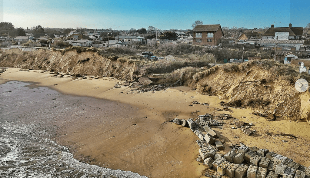
The Dunes have been further eroded with more sand stripped from the beach. Additional sections of Access Road have been washed onto the beach and an 8-foot Scarp (drop) created at Hemsby Gap. The Lifeboat service is temporarily out of service.

This comes after Hemsby Independent Lifeboat crew and Hemsby residents worked all weekend to place ‘Lego’ concrete blocks. The blocks were paid for by local Marrams residents, to try and stop erosion of sections of the dunes.

With every layer of sand that is stripped away, the beach gets progressively lower, this means the geographical point where Mean High Water sits on the beach is now over a metre lower than it was. Meaning the water level on the beach is a metre higher than previously when more sand was on the beach. Therefore, when stormy conditions occur, especially if they coincide with a high tide, greater volumes of water hit the beach.
Studies have shown that Total Water Level is a significant determinant of severe erosion on beaches in storm conditions. The same studies also discuss whether Storms that occur in clusters, can cause as much damage as a single storm, future discussions will consider the concept of Storm Clusters in more detail.
For now, fears remain that more erosion could occur tonight at Hemsby Beach. As winds forecast to the North, are significantly greater than predicted. The winds have changed direction to a North/North Westerly, but the strong winds could drive the surface of the water, elevating the height of a High Tide of 3.74 metres that was due for 7.36 pm on Monday 11th March. The concern would be if a surge and winds combined to hold a powerful body of water on the beach. Especially as a High Tide of 3.25 metres is forecast for 08:14 am on Tuesday 12th March.
Downing Street Petition
Members of Save Hemsby Coastline and Hemsby Independent Lifeboat Crew travelled to Downing Street on Monday 29th January to deliver a petition to call for a change in funding criteria for sea defences. In order for funds to be made available to proceed with a rock berm for Hemsby Beach.

Planning Permission has already been granted to install the rock berm, and it is believed that the berm would stem the coastal damage that has seen around 30 metres of dune lost in recent months. As well as the loss of properties with the trauma this causes and concern now for the future of the lifeboat station and neighbouring businesses.

With sizeable storm surges continuing in the North Sea, a constant fear of storms adds to the anxiety for those that remain on The Marrams. Particularly as a storm surge earlier in January 2023, removed significant amounts of dune, placing even more properties precariously close to the edge.
Surge Waves

As Storm Isha is forecast to hit, with extremely high winds and a storm surge of around a metre forecast for Monday 22nd of January, this discussion will attempt to look back at last weeks surge damage, as well as consider a wave type that can be damaging to dunes during storm events.
Firstly, is it the pain of the loss or the shock of the damage that is most acute after episodes of destruction such as that seen at Hemsby following the storm surge on 14th/15th January 2024.
After concerns following storms in late 2023, about the fragility of the dunes North of Hemsby Gap, a large section was completely removed overnight on 14th/15th January 2024. There are now real concerns about the viability of the Lifeboat Station, with alternative premises being sought. Though support has recently been offered which could help Hemsby Independent Lifeboat service.
Additionally, an extremely large amount of dune has been eroded along the whole length of the Marams.

More sections of access road have been washed away and properties on The Marrams now have a sea view, where was only dune before.

Additionally, properties that were set back from the edge of the dunes on The Marrams, before 14th/15th January, are now unfortunately perilously close to the edge.
Considering the damage caused by recent storm surges, it might be useful to briefly discuss a type of wave that occurs in Surge conditions that can result in dune erosion and overtopping in certain circumstances. The diagram below shows examples of Storm Impact Regimes and the sections of dunes they reach with a 2% and 98 % exceedance rate. Areas of dune are shown by D low and high refer to sections of the dune that can be reached by the Collison and Over wash regimes.

modelling of the collision regime
P.P.J. van Wiechen ∗, S. de Vries, A.J.H.M. Reniers, S.G.J. Aarninkhof
Delft University of Technology, Mekelweg 5, 2628 CD Delft, Netherlands
The wave types to be discussed are known as Infragravity waves (IGWs) and these will be looked at in a Collison Regime, which not surprisingly describes when waves collide with the surface of the dune. It is thought IGWs are created from wave clusters but this connection ends when short waves in the cluster break and rearrange in what is known as the Inner Surf Zone. This zone is nearest to the shoreline and can be seen as the changeover between the area where waves break and the Swash Zone.
The variety of speeds at which waves are moving, can cause a convergence of wave fronts, with some passing one another to form into a single wave front. This mechanism increases the phase at which the greatest energy of the wave is concentrated, the Dominant Wave Period. This in turn facilitates the transmission of velocity from the Short-Wave to Infragravity waves (IGWs).
It is thought IGWs can contribute substantially to dune erosion, because in the Swash Zone, the action of a wave when it runs back down a beach, (the Backwash), can generate considerable velocities which in turn elevate the quantities of sediment such a process can transfer offshore.
Additionally, the combined interactions of the crest of an IGW, the energy of Short-Waves, and turbulent actions within sea water, enhance the potential for IGWs to advance a greater distance inland. In turn, this can increase the levels at which waves can travel up a beach towards a dune toe. Greater amounts of soaking of the dune face can cause substantial amounts of material to slump from the dune surface. This mechanism can also move sediment from further up the dune into the Swash Zone and transport it offshore.
This process describes a complicated system of wave interaction, beach dynamics and sediment transport, which relates to hypothetical scenarios for storm wave interactions with dune surfaces. It relates to a combination of systems, which might not be applicable to every beach affected by a storm surge. Nevertheless, it begins to paint a picture of the dynamic, high-energy forceful interchanges between waves generated by surges, beaches and infrastructure, like roads and watermains. To attempt to understand why storm surges can so destructive, generating a sense of loss and shock as intense as the ferocious surge conditions that caused them.

New Year Surge
A Storm Surge on the evening of Sunday 14th January and the early hours of Monday 15th January has caused severe damage at Hemsby. A photo taken by Lee Jones, shows the final removal of a section of dune that separated the Car Park from the sea near the Life Boat Station. There is now a Gap with a sea view from the Car Park. More updates to follow shortly.

Surge Damage
Damage from the Storm Surge on Thursday 21st/Friday 22nd December 2023, along with very High Winds was extensive at Hemsby. Close to the Gap, about 2 metres of dune failed, alongside the removal of the Slipway used by the Lifeboat crew, so the Lifeboat is currently unable to launch. In place of the Access Ramp, a 1-3 metre Scarp was created at the Gap. The lifeboat crew hope to repair the gap on the evening of Friday 22nd of December, to hopefully bring the Lifeboat back into service.
In addition, less than 2 metres of Dune remain North of Hemsby Gap, meaning the Sea at High Water is perilously close to breaching the dune, putting the Car Park and Lifeboat Station at risk. More sections of the Access Road on The Marrams have also been destroyed, with stone filled wire Gabions taken apart past Newport.
The Surge and storm conditions were caused by an acute Pressure Gradient between a large anticyclone over the Atlantic and a deep low-pressure system over Scandinavia. A Surge in the ocean is caused by a drop in Low Pressure.

Concern exists about High Tide in the early morning on Saturday 23rd December which is due to arrive at 3:22 am with a height of 2.77 metres.

As the Damage Line at Hemsby, of weakened dunes, broken road, weakened infrastructure, and at risk properties collapses and retreats further. Potentially endangering Fakes Road and the fragile coastline at Hemsby.
Coastal Damage
Beyond Palings, beyond bridges
where settlement and sea
contend possession –
Wendy Mulford’s East Anglian Sequence 1998
On Thursday 21st December and Friday 22nd December, Storm Pia is forecast to hit Hemsby. The forecast for Thursday is for a Significant Wave Height (SWH) of 2.5 metres with high winds of 45-56 km/h, originating from a West/Northwest direction.

However, equally importantly, a storm surge of somewhere between 1.5 and 2 metres is forecast for the East Anglia Coast. High tide at Hemsby is at 2:23 pm on Thursday 21st December and the surge is forecast for either side of midnight on Thursday 21st/Friday 22nd December.

The forecast for Hemsby for Friday 22nd December is for wind speeds of around 40km/h, originating from a West/North-westerly direction. Significant Wave Heights are forecast to be around 2.4-2 metres, leading up to High Tide at 2:13 am, which will be 2.76 metres.

The concern is the size of the surge and the turbulence of the sea, with highest SWH forecast to coincide with High Tide on Thursday 21st December. With SWH set to continue, both until the surge arrives and on to the time of High Tide, early in the morning on Friday 22nd December. Agitated sea water could be held on the beach at Hemsby for a prolonged period of time which could jeopardise further the dunes and The Marrams. Though wind direction could mitigate against this.

It is the severely impaired state of beach, dunes and infrastructure, not to mention the demolition of homes recently inhabited by Marrams residents that has led to the thought that maybe Coastal Erosion should be reconsidered as Coastal Damage. As the jagged edges of broken pieces of road, hanging over into the void, above hollowed out scoured dunes, reveal weaknesses that could make them prone to further destabilisation in the next few days.

It is arguable whether channels formed on the beach that transport sea water across the beach, towards the dunes are signs of damage or indicators of damage to come.

As with the beach so low, the sea can carve, many fluid ways for tidal velocities to reach and attack the base of the dunes. Particularly as the beach is covered completely when the tide is in. As if it is thought that at Hemsby, as at a number of coastal locations, the beach has become the direct forceful interface between sea and land. The term Coastal Damage has the immediacy that is lacking in the description of Coastal Erosion, which can refer to gradual processes and systems.

For the beaches, dunes, infrastructure and people, caught in the interface between land and sea, it is the damaging ferocity of the sea that can determine the consequences of the high waves and storm surge forecast for Thursday 21st and Friday 22nd December.
Demolition

Just over two weeks after 200-metres of access road collapsed into the sea, 5 properties at the southerly end of The Marrams at Hemsby are due to be demolished this weekend.
Residents who until this week, called these properties home, include disabled full time resident Kevin Jordan. When Kevin moved into his property 14 years ago, he was told by hydrologist engineer colleagues he would have 100 years before coastal erosion became an issue. On Friday 8th December, he left his home to move into temporary accommodation in a village nearby.
Marie Smith is another resident who has had to leave her home on The Marrams with her daughter and move into temporary accommodation. It is the sudden loss and short time-period to decide what to keep and what to throw away that has been particularly hard for residents who will miss their properties and their view of the sea.

Headlines will claim the properties on The Marrams were demolished because of coastal erosion but is it useful to consider whether there are any similarities between definitions of coastal erosion and demolition.
Coastal erosion is variously defined as, the wearing away of the land by the sea, loss or displacement of coastal lands and landward retreat of the shoreline, and removal and transportation of eroded materials.
The term demolition can be described the action to tear down or break to pieces or smash. The term demolition can be described the action to tear down or break to pieces or smash. To deliberately destroy something, to build something else in its place.
In both definitions of coastal erosion and demolition there are references to wearing away, the destruction of a solid structure, but also the suggestion sediment removed from a beach, can be deposited to build up another location, just like a building may be demolished to be rebuilt elsewhere.

But as the 5 properties on The Marrams are pulled down over the dunes, to add, albeit maybe temporarily to the broken debris on the beach, left by the recent storms. It is hard to see how the structures of a home can be put together elsewhere. Similarly, it is hard to envisage any accretion (accumulation) of sediment at Hemsby, signs that could indicate processes of repair.

Therefore, through the destructive erosive processes that led to the collapse of the access road and the demolition of properties damaged as a result. Hemsby has experienced the wearing away and subsequent removal of vital infrastructure, homes and people. As coastal erosion and demolition seem to have combined to increase the precarious position of Hemsby. Exposing its vulnerabilities still further to the destructive power of the sea.

Broken Road

The community at Hemsby are reeling from the shock of the severe erosion that saw the collapse of a 200-metre section of road on Friday 24th November. At around 2:45, police were called to advise residents to move their cars to a safe location, about 2 and a half hours later, the access road had collapsed into the sea.
Seven days later, increasing numbers of residents on the Marrams are receiving section 77 letters from the council giving notice they must move out of their properties, as they are due to be demolished. One of the residents who have received these notices is Kevin Jordan, who lives at the most southerly point of The Marrams.

Regarding the sea state on Friday 24th November, the highest wave height, to date, was recorded up the coast at Happisburgh at 3.6 metres. The Storm Alert Threshold for Happisburgh is 2.74 metres. Wind gusts of 33.2 knots were recorded, with gusts of nearly 50 knots recorded at certain points of the day. It is believed at Hemsby, the wind was blowing the sea in the direction of the beach, pushing the sea towards the dunes. Friday 24th November came shortly after Storms Babet and Ciaran. But there was no named storm last Friday, no yellow weather warning.
However, residents at Hemsby and the Lifeboat Crew didn’t think the sea state was particularly bad, given what they have observed before. But nevertheless, the turbulence of the sea and strong winds contributed to serious erosion at Hemsby. North of Hemsby Gap, there is now only 2 metres of dune left between High Water and the Car Park. This could significantly increase the risk of a breach and place lifeboat station in further jeopardy. It is thought 60 ft of coast was lost at Hemsby in one night on Friday 24th November.
When dunes are eroded during storm surges, it is thought erosion begins once the dune face has absorbed a sizeable amount of water for a significant amount of time. As the wet sections of grains of sediment become a unified mass, this creates a gradient that exceeds the angle of the dry sand. The dune face steepens further until it is almost upright in relation to the scoured gash initially gouged into the toe of the dune. This creates an instability that eventually causes the dune face to fail, due to a mechanism known as Shear-type failure. If the weight of overhanging sediment or solid mass, becomes too heavy, this can cause large sections of sediment to fall down the surface of the dune.
However, it is also the steady, severe attrition against the dune face over many years, that has built up weaknesses and accelerated the erosion. It is therefore the rapid nature of the damage and the sheer scale that has shaken the community at Hemsby, and this could have implications for the wider coast and community beyond the Marrams.

Concern is being expressed about the viability of water mains and service provision following the damage on Friday 24th. Additionally, residents on Fakes Road and the Brick built houses behind the remaining dune at Hemsby are concerned about their properties having witnessed the severity of the erosion on Friday 24th November. The lasting effects of the erosion could be the destabilising uncertainty that residents, dunes, The Gap, are irrevocably altered, with the means to repair, out of reach, beyond a yawning gap across a broken road.
But considering the destruction, it could be useful to consider the term, Palimpsest. As perhaps in the lead-up to the anniversary of 2013, and all the erosion episodes in the past, it could be time to rethink coastal erosion. To think beyond the process as a gradual, sometimes serious, but measurable process. To begin to understand future coastal erosion as a rapid, sudden large-scale, unpredictable process, that can break, coastlines, communities and maybe even people. To begin to configure methods of adaption, before, it is too late to comprehend or repair the next broken road or coastline.

Friday 24th November

Recently it was announced resident Kevin Jordan, who lives on The Marrams, at Hemsby is one of several individuals joining Friends of The Earth to legally challenge Climate Change Adaption plans.
As if to amplify in an extreme dramatic manner, the loss and damage of coastal erosion that form the background to the court case, the latest winter storms have ripped through the dunes at Hemsby. A storm surge of around 1 metre for the East Anglia Coast was forecast along with very high wave heights and strong Northerly winds.

Waves have stripped sand from the dunes, with around 20 ft (6 metres) lost from the North of the Gap. The watermains relied on by residents has been destroyed and many homes in the surrounding area are without electricity.

Additionally, waves have caused the large-scale collapse of a 200-metres section of road along the Southern Marrams, isolating many vulnerable residents.

Damage in a storm when so much has been shattered, can be summarised as the sudden forceful destabilisation of fragile, mechanisms that could no longer withstand the force of the waves. In a high-energy dynamic coastal environment, where nearshore systems create and re-create fluid sandbanks and channels to direct tidal velocities to rip away the surface of the beach and destabilise the dunes.
Loss is experienced in a number of ways. As Kevin Jordan comments in the video below, residents such as himself are likely to be the last observers of the coast as it was. Sustained attrition, gradual, sometimes rapid, removal of the elements that make a life, change perceptions on The Marrams. Residents comment that they use fence posts as assurances of their position above the dunes. As houses are demolished around them, this changed the significance of the fence posts.
But when the power of the ferocity of the sea has been unleashed against a vulnerable coastline, ways of life and infrastructure relied on by communities have abruptly lost their function. Suddenly, pulled away by the aggressive Backwash of a storm wave on a steeply sloping beach. Out into the turbidity of the sea, with no reference points, because the effects of climate change are new, and unpredictable.
If coastal communities such as Hemsby are erased, is there a loss also of the observers, those who understand what is occurring and what is changing out in the sea. As areas of the coast face deletion, is it possible there could also be a loss of the landmarks, the measure of the erosion and behaviour of the sea. A loss of ways to determine the unfamiliar forces remaking and damaging ever more of the key elements of the coast.
Between the sea and the sky
As storms continue to batter the East Anglian coastline, this video brings a really interesting human perspective to life on the Marrams at Hemsby. Concern about the vulnerability during storms but also a glimpse into the variety of wildlife to be seen looking through binoculars up on the dunes.
Storm Ciaran
On Saturday 28th October, as an unfortunate casualty of Storm Babet, the last remaining home on the Northern Marrams at Hemsby was demolished, the sixth property to be demolished this year.
Storm Ciaran brought more High Seas and Waves to southern coasts of the UK on Thursday 2nd of November. Significant Wave Heights at Hemsby were forecast to be 2.4-3 metres, with wind speeds of 50-70 km/h, blowing in a Southerly/South-easterly direction.

Regarding damage to the dunes and beach, the photo below shows considerable scouring into the face of a dune, below a residents property. They believe that 20 feet (6 metres) has been lost from the dune face in the last 6 months.

At Hemsby Gap, concrete Lego blocks were placed on top of the existing 8-10 ft tank blocks, to try and reduce the power of the waves. But it is believed that the force of the waves, lifted the Lego blocks off the tank blocks and deposited them further up the beach. The photo below shows that more sand was scoured from behind the tank blocks as a result of Storm Ciaran.

However, it is thought Hemsby has survived the worst effects of Storm Ciaran, but fears remain for the basic infrastructure that supports properties on The Marrams and the wider communities in the area.
As it is the constant attrition in a high-energy environment, that takes away a piece of dune, metres of sand at Hemsby Gap, chips away at the remaining access road, and disables a water main. This constant gnawing and dragging away of key elements of a community. As its isolated parts try and hold together as winds and waves pound away at the elements that keep it together.
Sticking Plasters against the Waves
Forecast high winds and waves hit Hemsby with some force on Friday 20th October 2023. The video below shows the sea state at Hemsby Gap when the high tide measuring 2.82 metres arrived at 10:50 am.
https://www.facebook.com/1200394065/videos/pcb.5873627936073212/1379385286281140
The Independent Hemsby Lifeboat Crew and residents were on duty 24/7 to observe sea, dunes and beach, ready to deal with erosion damage. The photo below captures the watchers of the high seas at Hemsby Gap.

The lifeboat crew have buried, what look like concrete lego blocks, into the sand at Hemsby Gap, behind the much larger stone blocks that stand 8-10 ft tall (see photo in Visit to Hemsby piece below). The intention with burying the concrete blocks, is that if the sea cuts in behind the larger defences, it will hit the concrete blocks and hopefully not scour out the sand, damaging the vital access slope used by the Lifeboat crew to launch out to sea.

Meanwhile, ariel photos taken by Luke Martin Photography, give an indication of the extent of the erosion of the cliffs as a result of the storm. In the photos, it is also possible to get an idea of the vulnerable section of beach to the North of Hemsby Gap.
One casualty of the storm has been the loss of the remaining property on this section of the Marrams. The property has been marked for demolition.
Following Storm Babet, concerns are heightened about the narrow strip of remaining dune, in between the property due for demolition and Hemsby Gap. Only a few metres of Dune remain and the Lifeboat crew are drawing up contingency plans regarding the Lifeboat Station. As there is a very real fear that a bad winter storm, could cause a breach in the dunes, which could permanently damage the car park behind, which is below sea level. Such a breach would also obviously, severely damage the Lifeboat station, positioned just beyond the entrance to the car park, just back from the Gap.

The first major storms of the winter that lasted for a period of 7 days from the 13th to 20th October has torn away even more chunks of dune and another property at Hemsby. In what many fear is a sign to things to come on this vulnerable coastline, despite the ingenious work to apply sticking plasters to mitigate the damage of wave action. As the sole actors that would attempt to stem the erosion, find themselves positioned as involuntary observers, as metres and metres of sand and coast slip endlessly away beneath the waves.
Before the Storm
Conditions for Hemsby, for Friday 20th October are forecasting significant wave heights of 3.5 metres with wind speeds of up 60 miles km/h, with predominantly a Easterly wind direction.

Ahead of a potentially severe storm forecast going into Friday 20th, this discussion will seek to pull together a few concerns about vulnerable points on the beach and a few physical features that could act as contributory factors.
This video taken by Hemsby Beach Café, shows high waves arriving this morning at Hemsby Gap, during low tide.
As has been commented on in updates below, the most vulnerable areas of the beach, are the sections about 100/200 metres either side of Hesmby Gap, particularly the area to the North below the 1 remaining property on the North side of the Marrams. The Hemsby Independent Lifeboat crew have moved the Blocks previously protecting Hemsby Gap to the section of dune below the at-risk property.
There is a real concern that there could be a breach in the dune which could impact The Valley area behind the dunes and potentially endanger the Lifeboat Station itself. The volunteer Lifeboat crew have committed to monitoring the beach/dune situation 24/7 for the duration of the storm.
High waves in recent days have already gouged out the dune surface below the access road on the Southern Marrams. There is concern for the Water Main on this section of beach, as it serves 9 properties on this section of the Marrams.
Features that make the high sea events so acute and potentially damaging include the tendency for the tide/turbulent sea state to be held in the beach, thereby exacerbating the erosion strength of the sea. It is thought that this occurs due to a combination of factors which make up a perfect storm of high wind speeds from a easterly/north easterly direction, alongside significantly raised sea states, sustained by any combination of waves/tides or surges.
Additionally, the topography of the seabed, with peaks of sandbanks and channels and an undulating sandy nearshore surface, that constantly changes, focus velocities of sea water, and the directions and rhythms of the waves.
In the last month or so, the sea on Hemsby beach breached through a sand bar into standing pool behind, with the clear line of a sandbank channel running along the beach. This was located just North of Hemsby Gap.

A new sand bar has also formed North of the Gap, this is associated with the movement of Winterton Ness to the North, which seems to be causing a number of new channels to be moving on the sea floor.
In conclusion, it would seem in this dynamic, high-energy interface, the question could arise, how should this constant tug of war be managed, in this contested space between sea and land. To manage only the land risks the ungoverned sea, encroaching and overwhelming the land. To only manage the sea, to mitigate its effects on the land, could enable accretion and growth of beach and dune. But to govern and hold back the ocean, could prove to be an enormous task.
But to not manage either land or sea, could enable one force to gain advantage of the other in ways that are hard to predict. It is thought the sea is seeking to reclaim space on the land, in a process known as transgression. To gain a new equilibrium, it is seeking a higher beach formation by gouging out the dunes. If this process occurs in an unmanaged form, with naturally higher levels of sea arriving at the beach, it is hard to know how the sea might take control of the land. To what level it might take this advantage, at the expense of the existing dunes or local communities on the coastline.
Wind and Waves
Conditions continue to remain very precarious for residents on the Marrams and for the dunes and beach levels at Hemsby. Forecasts today predicted Significant Wave Heights of 1.2-1.6 metres with winds of 25-40 km/h blowing from East Southeast direction. Hight Tide is at 09:20 pm with a height of 3.08 metres.

There is concern if the tide is held on the beach by the North Easterly winds, which are forecast for Friday 20th and Sunday 22nd October, with wind speeds of around 25/50 km/h, with the addition of extreme wave heights. These conditions pose a real risk to the dunes and properties and infrastructure on The Marrams. However, there is a slight possibility, that if weather and sea state conditions, are particularly severe, this could create a breach in the dunes, particularly around the area, about 150 metres north of Hemsby Gap. This could be problematic as the area behind used by dog walkers, is below sea level.
It is the vulnerability of the beach and dunes that make the forecasts of severe weather and sea state so concerning in the coming days for the community at Hemsby.
Unlucky Erosion

The date of Friday 13th proved very unlucky for the Hemsby Coastline as it has saw the start of a severe erosion episode which continued for 3 days, with at least around 5 metres of sand eroded from Hemsby Gap. A drop, known as a Scarp of about 6 ft (1.8 metres) was cut into the sand slope that Hemsby independent Lifeboat Crew use to access the beach. This erosion feature temporarily prevented the Lifeboat Crew from launching their lifeboat from Hemsby Beach.

As a result of the erosion episode that started on Friday 13th, it is thought around 3-4 metres of dunes have been lost to the North and South of Hemsby Gap. The lifeboat crew have warned there is a real risk that parts of the Dunes immediately to the North and South of the Gap could collapse and they are warning residents and visitors to be extra vigilant.
In addition, 1 resident was evacuated from their property, but has since returned. About 8 more properties temporarily lost their water supply, due to wave action causing erosion that broke the Water Main. The lifeboat crew and others worked throughout the day on Sunday to repair the Water Main. It is also thought only 15 metres remain, of the remnants of the basic access road on the Marrams.
To give an idea of the amount of sand that has been lost, the first photo below shows the level and width of the top of the sand, when the photo was taken in the middle of September.

This second photo shows the erosion that occurred on Friday 13th /Saturday 14th October 2023:

The Sea State for the night of Friday 13th, was for a tide height of 2.86 metres at 7:28 pm, with Significant wave heights of around 1.1/1.4 metres. On the morning of Saturday 14th October, the tide height was 3.17 metres at 7.27 am, with Significant Wave Height ranging from 1.6 to 1.8 metres. A member of the lifeboat crew at Hemsby, observed that the weather conditions on the night of Friday night/Saturday morning caused the tide to be held longer than normal in the beach area of Hemsby.

In addition, a Surge at Lowestoft, a few miles down the coast from Hemsby, down in Suffolk, was forecast to be about 0.8 metres high for the early hours of the morning of Saturday 14th October 2023.

Tide heights on Sunday 15th October were 3.26 metres at 7:58 am with Significant Wave Heights forecast to be around 1.7-2.1 metres high. As it is the time of Spring tides, where tide heights are naturally elevated, it is concerning that weather predictions for Wednesday and into the weekend look to indicate conditions that could cause further erosion.
Visit to Hemsby – 17th September 2023

Visit to Hemsby
High tide on Sunday 17th September was at 08:57 with a height of 3.3 metres, but on arriving at Hemsby Gap, around an hour and a half later, large waves were still pounding blocks installed to try and stem the erosion. Waves appeared to bounce off the blocks and clash with incoming waves.

When waves hit a hard surface, spray shoots up, but an equal amount of energy also travels down to scour the beach surface. Spray propelled forward by force, surges behind the blocks, cutting into the sand, causing the line of the Scarp to retreat, increasing the gap to the blocks in front.

The height of the sea and the power of the waves is put into perspective, when standing in front of the blocks at low tide. Standing at around 10 ft tall, they look imposing, but the power of the waves is still visible, as a hazardous metal loops wrenched from the blocks appear to now be wedged into the sand.

However, it is only when as a first-time visitor, walking through the southern Marrams, you begin to wonder about the meaning of the words fragile, vulnerable and precarious in the context of the homes that remain on the dunes.
The term fragile, is a useful description of the increasing difficulties residents experience as they constantly stretch to accommodate ever more difficult, alterations to living practicalities. Due to coastal erosion, life is tenuous, with constant awareness that less than a year ago, several properties were demolished following the big storms in February and March 2023. A reality recently described in an article about Marrams resident Sue Slatford, whose house was demolished following the storms earlier this year.
Vulnerability refers to the instability of the coastline. In places the temporary, replacement road is level with the thin remaining dune.

Dunes are eroding below the road, with a notice on the fence to warn beach goers to stay away from the cliffs.

The old access road that served the recently demolished houses leads only to the void, of damaged cliffs, and the pounding sea that washed it away earlier this year.

For Hemsby, with nothing to attenuate the power of the waves, symbolises the precarious, forceful interface between land and sea. At both ebb and high tide, the beach can be frequently covered with water, with both intertidal and supratidal zones regularly dominated by the flow and turbulence of the tides. Due to its low beach profile, waves regularly reach the toe of the dunes, resulting in dramatic losses. One resident bought their property in 2009, with the shoreline around 91 metres (300 feet) away, by 2023, the cliff edge is now around 21 metres (70 feet) away.
A sign hanging on the fence at Hemsby Gap, has been ripped in half a useful metaphor, perhaps for a community who fear the future of the coastline hangs in the balance, in this place of tumultuous sea and shifting sand.

The first week of August 2023, saw two deep area of low pressure in the United Kingdom generate a period of severe weather, including the first named UK storm of 2023, Storm Antoni. Sea State conditions saw large waves and high tides of between 3.5-3.9 metres at Hemsby. With reports stating that around 3-4m (10-13ft) of beach were lost as a result of the storms.

