
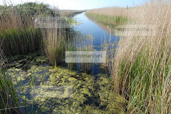
On the right-hand corner of Iken marshes, there is a freshwater marsh nature reserve, near Stanny House Farm, just below the Alde Mud Flats, on the Alde Ore Estuary.

The reserve is home to Marsh Harriers and Lapwings, as well as Bearded Tits, which nest in the Reedbeds.
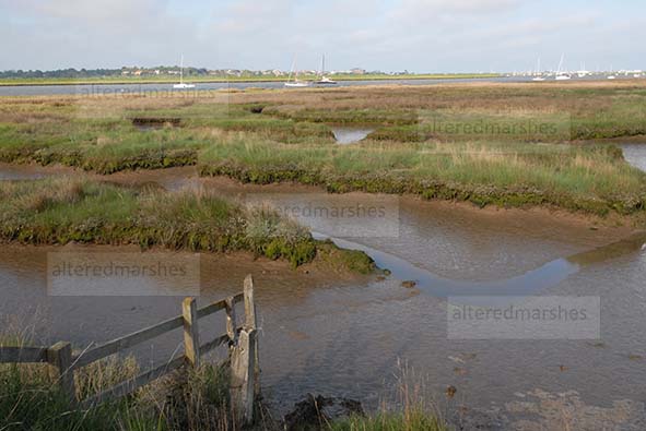
It is on the right-hand side of what is known as Flood Cell 5. Areas at risk of flooding, on the estuary are divided into cells to assess their vulnerabilities. The reserve offers an example of the use of saltmarsh in front of flood defences. Several studies have assessed the usefulness of this form of flood defence, particularly in relation to sea level rise (SLR). It has been found that saltmarsh can dissipate wave energy, but it is debatable whether this would continue under a SLR scenario. Latest predictions for seal level rise, forecast that Global Mean Sea level could rise to at least 0.29-0.59 m for a low emissions scenario and 0.61-1.10 for a high emission scenario.

It is undoubtedly the case that, where saltmarsh is absent in front of a flood defence, there can be found examples of erosion at the base of flood defences and into the concrete revetment installed as a means of flood defence.

Where tidal water reaches right to the bottom of flood defences, the tide can rise quite high, with the full energy of the waves, potentially weakening structures and embankments.

To encourage vegetation as an initial method to develop saltmarsh, groynes are inserted, to enable vegetation grow, in between the groynes and the base of the flood defence.

Two studies into the performance of saltmarsh under SLR, have reached different conclusions. A study by Moller et al, found that Saltmarsh offers substantial wave attenuation, even when tide levels are elevated and waves heights increased. When waves compress and rupture vegetation stems, diminishing the loss of wave energy, the actual base of the marsh remains firm and resilient to erosion (Moller et al, 2014).
However, a study by Best et al, concludes that ultimately, saltmarsh vegetation, that form flood defence systems, will be unable to withstand SLR. As wave transportation of sediment to the saltmarsh, increases its height, wave momentum, becomes focused on the Mean Sea level, which can increase erosion. Channels accelerate movement of sediment within the saltmarsh, with increased wave heights decreasing the width and increasing the height of the saltmarsh. Eventually, channel networks reach further towards the land and carve into the saltmarsh. If the saltmarsh is unable to adapt to SLR, vegetation will be pushed towards the land, to accessible areas of higher ground. SLR can increase water levels, enabling waves to travel further into the saltmarsh. A bigger tidal prism, results in greater wave energy, contributing to increased sea facing erosion and further landside sediment deposition (Best et al, 2018).
It is unclear whether this process can be said to be occurring within the saltmarsh at the nature reserve on Iken marshes, near Stanny Farm. A study by Kearney and Fagherazzi, 2016, has found that channels in saltmarsh can encourage the swapping of water, nutrients and sediment amongst saltmarsh and estuary, which can boost vegetation.
The Iken marshes nature reserve, below the Alde mudflats, provides a good case study of managing saltmarsh and clay embankment flood defences whilst sustaining freshwater reserves. While the nature reserve is a tranquil space, the dynamic of SLR means the nature must co-exist and may ultimately be shaped by the high-velocity tidal systems, already eroding its edges.
