
Few areas are more susceptible to large dangerous storm surges than the southern part of the North Sea.
Storm surges, 1967–1982. N. S. Heaps. Geophysical Journal International, Volume 74, Issue 1, July 1983, Pages 331–376.
This discussion will begin a two-part consideration to look at storm surges. The first part will discuss the effects on the East Anglian coast of two surges that occurred on 24th November and December 21st/22nd 2023. The second part will debate the extent to which storm surges possess a particular strength with the ability to cause significant long-term damage on a coastline. This 2nd part will debate contributory factors to the potential power of surges, with reference to the slightly different meteorological conditions that produced the surges in November and December.
On Friday 24th November, a storm surge measuring over 1 metre was forecast for Lowestoft, with similar forecasts in place at Cromer and Felixstowe.
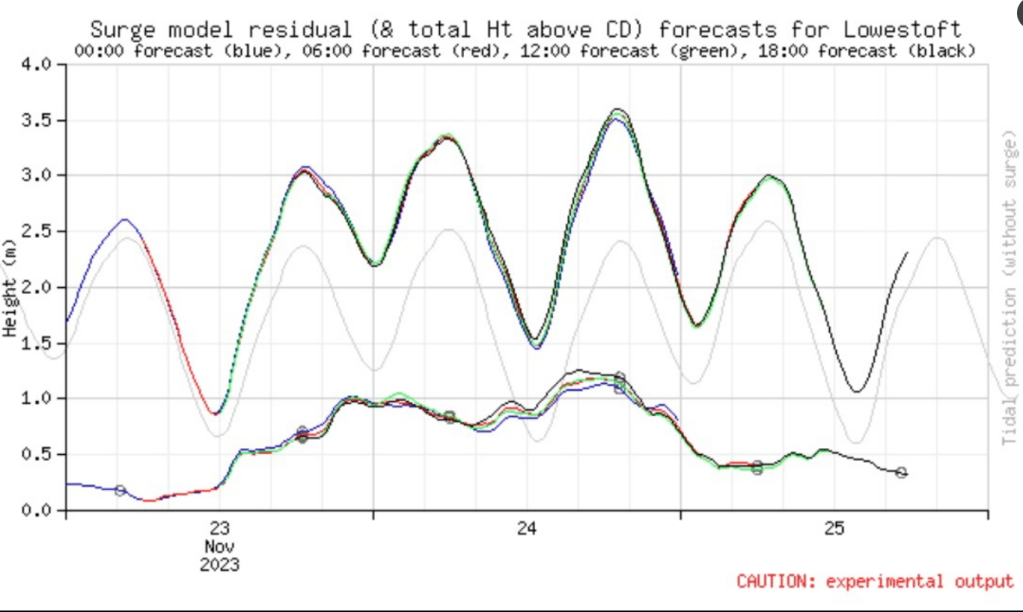
(NTSLF) https://ntslf.org/storm-surges/surge-forecast
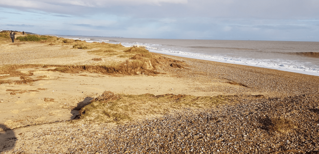
In the time period of the surge several significant erosion episodes were recorded. Particularly significant damage occurred at Hemsby in Norfolk and Pakefield in Suffolk, where large sections of access road used by residents at both locations, collapsed into the sea.

In other areas of Suffolk, At Minsmere RSPB nature reserve, the surge overtopped the dunes and temporarily washed into the nature reserve before draining out within 2 days. Sea water from the surge, flooded the beach fence line, with the sea seeming to break through sections of dunes in places.
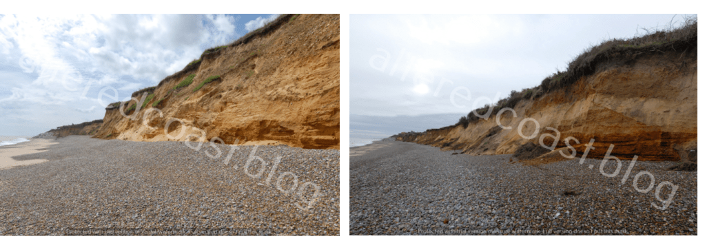
At Thorpeness, the surge seemed to level the length of the cliff frontage, with a noticeable difference in beach profile from photos taken on November 5th and 26th November 2023.
At Sudbourne beach, the shingle ridge appears to have further flattened out, with two wide fans of shingle that appear to stretch towards the water channel behind the wall that protects the Alde & Ore Estuary. In the estuary itself, the surge caused a greater volume of water than usual to flood the saltings for prolonged periods of time both before and after high tide.

The second storm surge occurred as Storm Pia hit the UK. between midnight on Thursday 21st December and the early hours of Friday 22nd December 2023. A storm surge measuring around 1.7 metres was forecast for Lowestoft.

(NTSLF) https://ntslf.org/storm-surges/surge-forecast
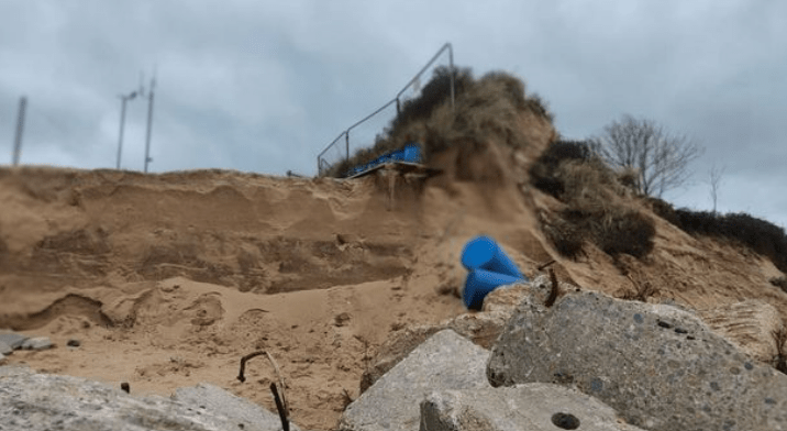
At Hemsby, damage from the surge included scouring of around 2 metres of sand from Hemsby Gap, and the formation of a 1-3 metres Scarp. Additionally, less than 2 metres of dune remains North of Hemsby Gap, with a car park and Hemsby Independent Lifeboat station, immediately behind this section of dune. The damage to the slipway has meant that Hemsby Independent Lifeboat has been out of service.
Another significant feature of the December storm surge was the tide locking effect that occurred on the Norfolk Broads. This meant water that would naturally drain out into the sea from the Broads was prevented from doing so because of the volume of water coming up the rivers from the storm surge in the North Sea.

Two weather system maps for the storm surge on Friday 24th November and Thursday 21st December, provide a useful framework for the debate in part two of this discussion, as conditions show some similarities as well as significant differences.
On Friday 24th November, a low-pressure system was located off the East Anglian Coast, whilst a high-pressure system was located over the Atlantic. At Happisburgh low pressure dipped to 1016 mb between 10:50 and 15:20 on Friday 24th November. A Significant Wave Height of 3.6m was recorded at Happisburgh.

On Thursday 21st December, again a low-pressure system was located off the East Anglian Coast, whilst high-pressure was located over the Atlantic. However, the pressure gradient was much steeper, with low-pressure deepening to 997 mb between 07:30 and 08:00 am on Thursday 21st December. SWH also remained below the Storm Alert Threshold on Thursday 21st and Friday 22nd December 2023.

It would seem to be apparent that the two storm surges in November and December, were produced in slightly different weather conditions, but both surges had a significant effect on the coast and inland tidal estuaries. Therefore the 2nd part of this discussion will consider the potential specific strengths of a storm surge and debate this phenomenon with reference to meteorological conditions and likely sea state features that can make surges so damaging.
