“Playthings for the waves of the North Sea”

Shadowlands. Matthew Green

A piece of broken flood defence with notches in the cliff and gouging of cliff surface. Thorpeness 14/04/2022

The penultimate discussion in the series to consider whether large events or small gradual processes contribute the most to coastal erosion, will look at the beach and cliffs of Thorpeness. This area has been subject to gradual long-term erosion, but it is also a dynamic high-energy location where several metres of cliff can be lost in a single storm event. The following features cliff, beach, waves, sand banks, sediment, storms and erosion, will be explored, as they are part of the constant taking apart and altering that occurs at Thorpeness.

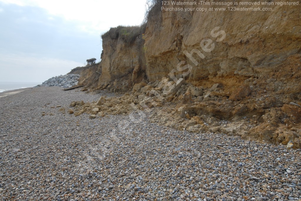
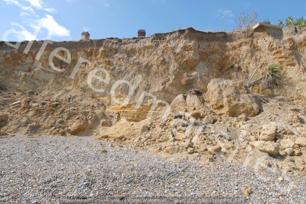
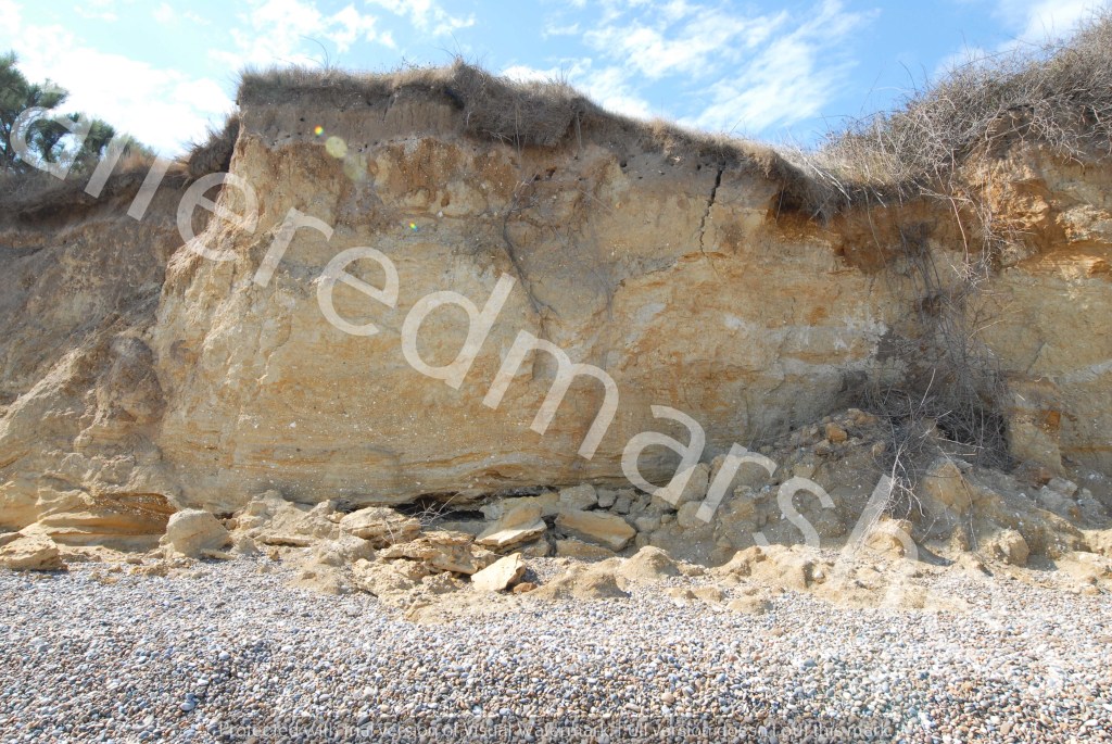
To begin with the cliffs, it is useful to consider the geographical make-up, to get a sense of structure. At the top can be seen, glacial deposits of sand, gravel and clays, thought to have been deposited by the Anglian Ice Sheet, around 450,00 years ago. Underneath is a layer of Norwich crag, comprised of marine deposits of fossil shells, bands of yellow and brown sands and clay. The penultimate layer is Red Crag, mostly courser sand and gravel, and this lies on harder Coraline Crag.

Eroded cliffs below Red House, Thorpeness 27/08/2022

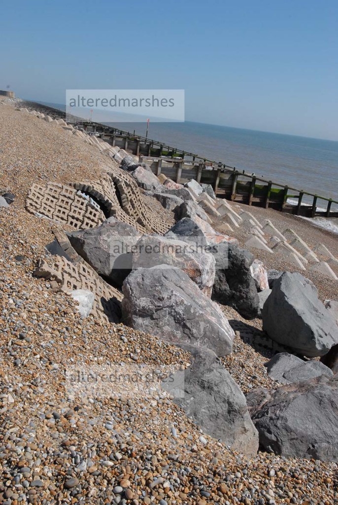
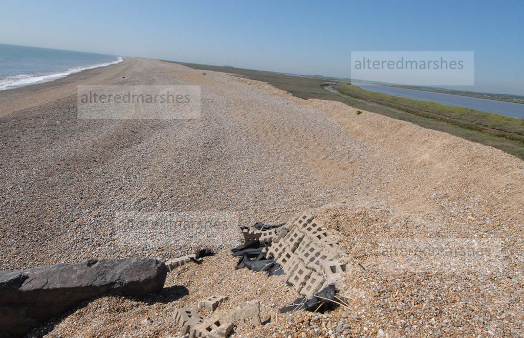
The cliff composition gives a picture of how they could be manipulated by waves. Two papers’ Deriving mechanisms and thresholds for cliff retreat in soft-rock cliffs under changing climates: Rapidly retreating cliffs of the Suffolk coast, UK and the Shoreface Dynamics on the Suffolk Coast Marine Research Report find North Easterly winds produce higher waves with greater propensity to scour beaches. Damaging events can occur when NE waves record Significant Wave heights (SWH) that reach or exceed 3.11 metres, as waves of this height have the potential to move substantial amounts of beach material. For example, the event on 31st March 2022 where SWH exceeded 4 metres at Lowestoft caused considerable damage. Storm Surges can produce conditions capable of generating such waves, but they tend to cause damage in different places, in different ways.

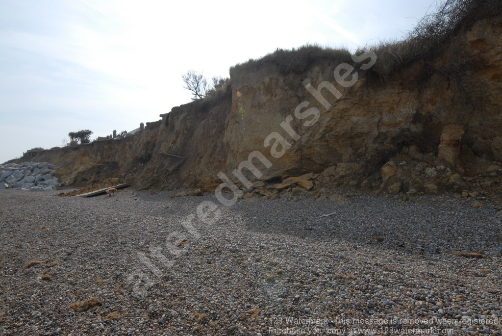
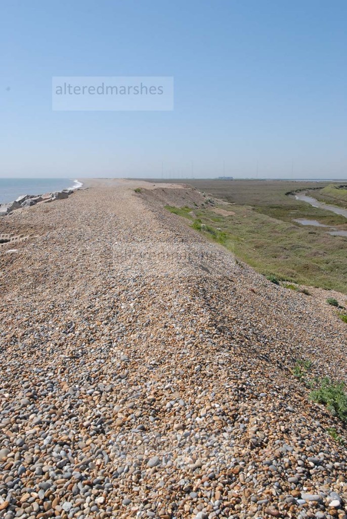
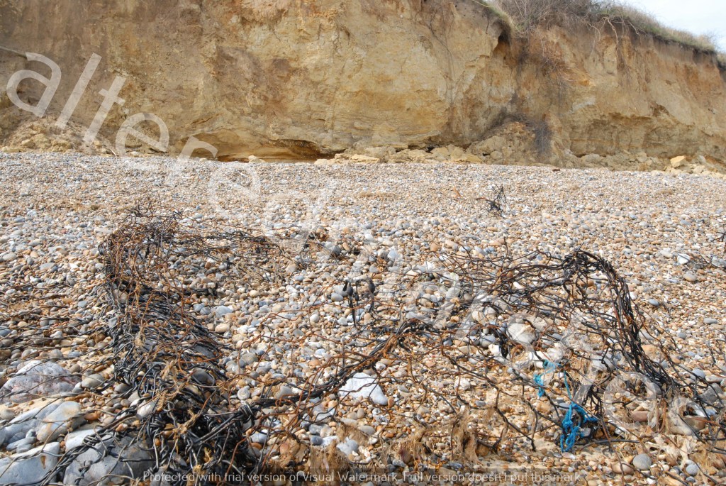
Sediment transport is a significant feature at Thorpeness. The paper above to discuss cliff retreat, suggests low-level southerly waves, transport sediment in a northerly direction, possibly nourishing the Sizewell-Dunwich sandbanks. But NE waves scour sediment and transport it in a southerly direction. If we think of erosion as the removing of sediment and the depositing of this sediment at a separate location, then this is the constant process at Thorpeness. This could be why the width of the beach is so narrow, particularly where the most acute erosion occurs. At times the beach appears to be stripped of shingle, whilst at other times, shingle is piled up in ridges at the back of the beach. However, whatever the sediment situation, there appears to be hardly any distance between Mean High Water Spring (MHWS) and the base of the cliff.

View of Thorpeness Beach, with Rock Flood Defence, Shingle Ridges and Red House. 27/08/2022

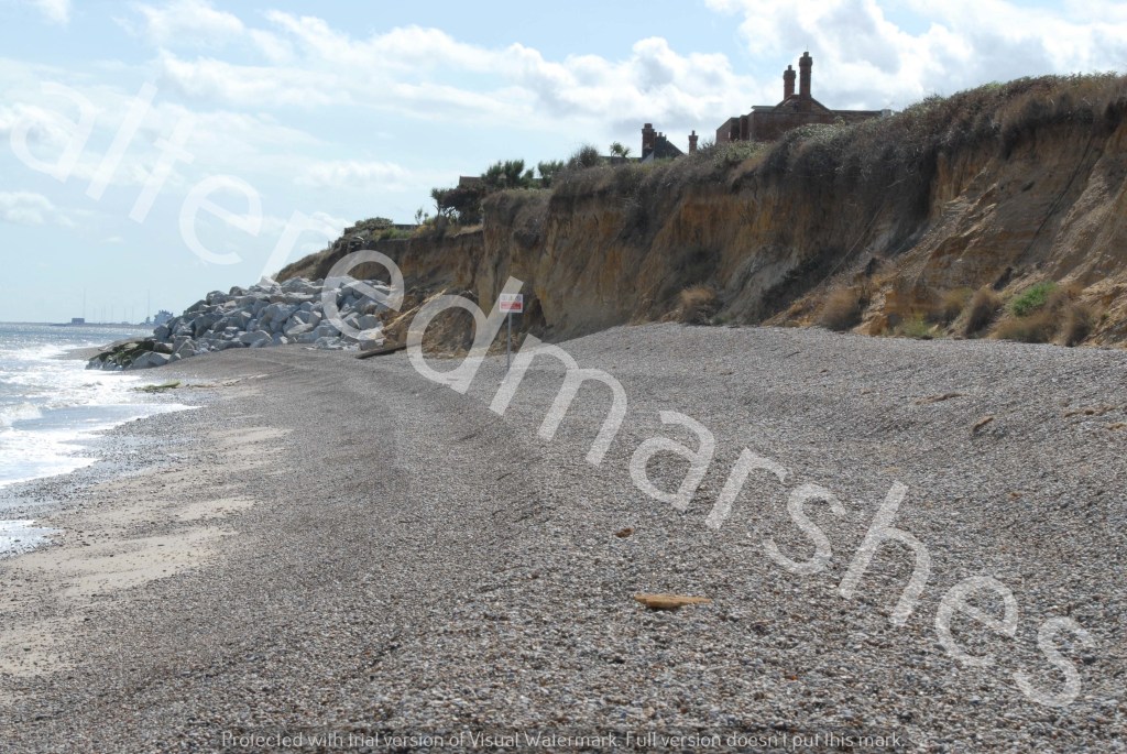
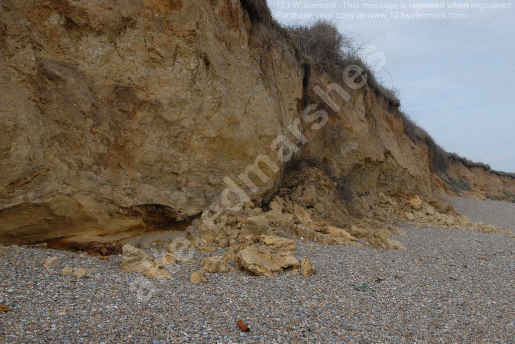
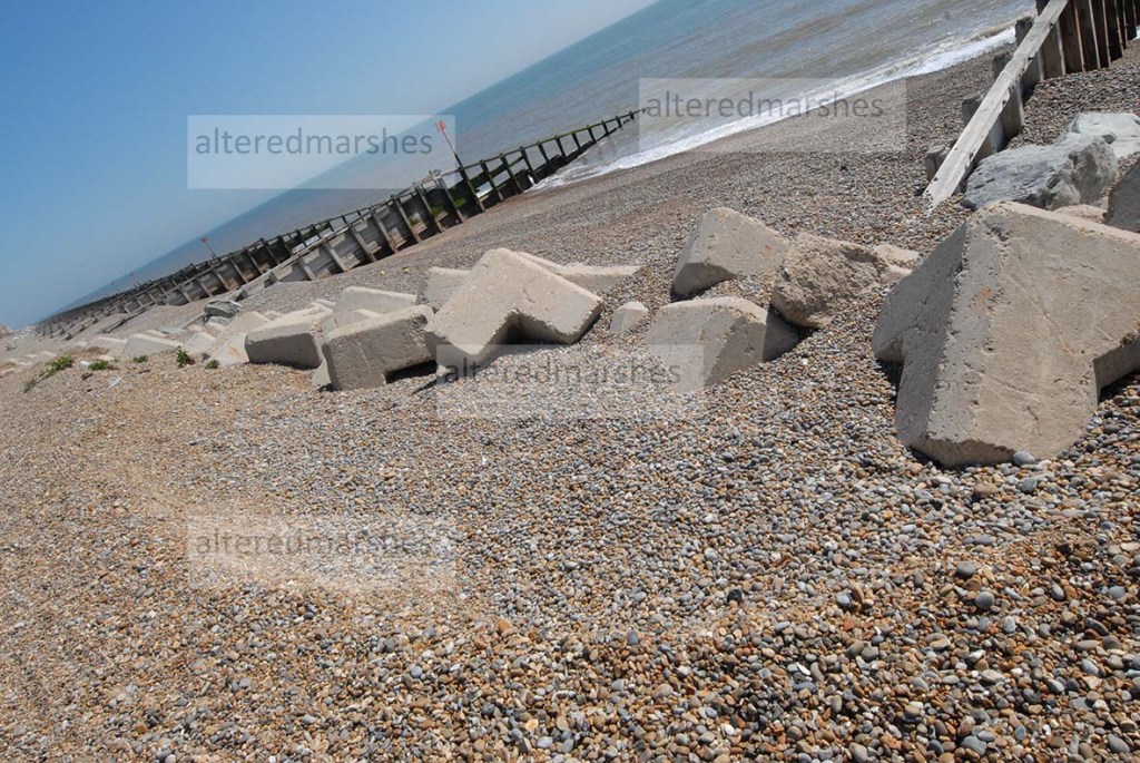
Features of erosion include notches in the beach and base of the cliff and removal of substantial sections of cliff frontage. There is considerable slumping of debris from the top and the bottom of the cliff deposited on the beach, along with trees, turf and concrete slabs from gardens above.  

Each feature discussed above contains complex properties that interact and evolve on this coastline. High wave events could weaken cliffs and cause cliff retreat, in the years that follow storm events. But perhaps it is too simplistic to identify large erosion events as the cause of erosion. Fragile composition of the cliffs could mean they will inevitably erode over time. The beach constantly changes, when shingle accretes, this could mitigate erosion.

Notches in the beach and base of the cliff, Thorpeness. 27/08/2022

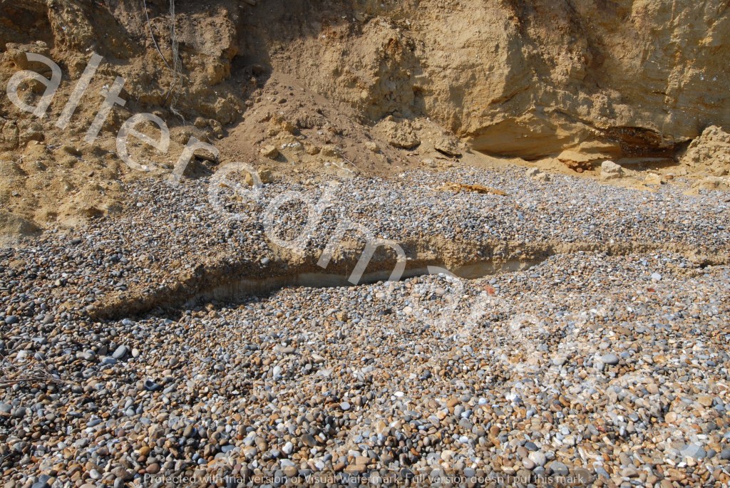
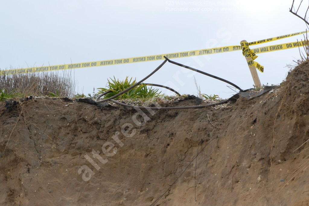
New notching into the beach, widening of notching at the cliff base and new desiccation cracks in August 2022, occurred during summer months when very few storm conditions were recorded.

Desiccation Cracks in Cliffs at Thorpeness. 27/08/2022

But it is the severity of the erosion during high wave events and the significant way they change the cliffs and beach, that suggest these events contribute most to coastal erosion. Particularly as they make mechanisms of recovery hard to envisage at Thorpeness. Complexity of the erosion and the characteristics and frequency of high wave events set the scene for the playthings of the North Sea.

Perceptions of Erosion

Erosion into shingle ridge, at top of concrete block flood defences, Sudbourne Beach, near Aldeburgh

This discussion is the second of a series, to debate whether big events, such as surges or high waves, or smaller gradual processes, cause the most erosion. This second conversation will look at erosion at Hazelwood Marshes in the Alde and Ore Estuary and Sudbourne Beach on the open coast. These areas have been selected because they provide examples of both small- and large-scale erosion. To frame this discussion, an initial definition of erosion will be used that describes it as a process that takes away physical substances, from the earth’s surface, mainly earth, sand or shingle and conveys this sediment by weather driven process’s such as wind or water from the focal point being eroded.

To begin with a consideration of Hazelwood marshes, it is necessary to acknowledge an immediate contradiction in the context of a discussion of whether erosion is caused by large- or small-scale events. As anyone who knows the history of Hazelwood, knows the reserve used to be a freshwater marsh, but was made intertidal on 5th/6th December 2013, when a large storm surge, caused the embankment flood defences to breach, leading to a permanent inundation of sea water into Hazelwood marshes. Therefore, it could be said that it is case closed, it is the large-scale flood events that cause severe erosion.

But in the case of Hazelwood, since the storm surge breach in 2013, it could also be said it is the gradual, small actions of waves, that could be significant. When you walk along the raised path to the bird hide at Hazelwood, when the tide is coming in, there is a noticeable change as the tide water which has been silently creeping in begins lapping at the side of the bank below the path. It is this constant movement, the tiny incremental expressions of energy, that could be said to be nibbling away at the banks on the reserve.

Erosion on the side of path facing the estuary, on the way to bird hide at Hazelwood Marshes

In the last few months, Suffolk Wildlife Trust who manage the reserve have removed a line of dead blackthorn trees and scrub scoured by intertidal salt poisoning. The materials were removed so they could be used to help support the structure of the path to the bird hide and infill some eroded sections. Erosion of the grass banks at the back of the reserve, below the holiday property, Marsh View is also visible.

Scouring into grass bank at back of reserve at Hazelwood Marshes

It is also noticeable how high the tide line appears to be, continuing the discussion of whether it is significant high water or the gradual actions of waves, that is causing the most erosion at Hazelwood.

High Tide line at the top of eroded grass bank, at back of reserve at Hazelwood Marshes

At the open coast at Sudbourne Beach, it is a more complicated picture. The coast is currently separated by a narrow shingle ridge from the Alde & Ore estuary. On the first section of shingle ridge from the Martello Tower towards Orfordness, various flood defences are deployed, such as concrete mattresses, concrete blocks, and large boulders. However, beyond a certain point, the flood defences stop, and the shingle continues without further defences.

The processes of erosion are two-fold. Above the various flood defences, there is significant scouring into the top of the shingle path, making it quite narrow to walk on. Proof, if it were needed, that the North Sea has never had much respect for flood defences.

Erosion at top of Concrete Blocks deployed as Flood Defences on Sudbourne Beach, near Aldeburgh

However, on the section of shingle not protected by flood defences, the shingle ridge has been pushed quite far back and there is evidence of a recent breach at the top of the ridge that separates the beach from the Alde & Ore estuary. It is likely this breach occurred during the high tides in January and February 2022.

Breach in Shingle Ridge, separating open North Sea from Alde Ore Estuary, Sudbourne Beach

To consider the erosion at Hazelwood Marshes and Sudbourne Beach, it is useful to further develop the definition of erosion discussed above. Whilst it is clear that sediment is being removed from the specific areas discussed, it could be said there is also a process of altering, noticeable losses of solid structures.

Therefore, to conclude the second debate in this series, to consider whether erosion is caused by large scale or small processes, the conversation could simply be a discussion about stages of damage. The incremental continuous damage to coastal features or the sudden forceful visibly recognisable events that create a hole or a channel through a seemingly firm feature. Assessment of this damage, as a one-off specific occurrence, or the culmination of damaging processes, could frame an evaluation of the significance of erosion in vulnerable coastal areas.

Flood Embankments – cracking in the heat?

In the lead-up to the two-year anniversary of alteredmarshes, a series of discussions will consider whether it is the big storm surge events that cause the most coastal erosion, or smaller processes that develop over a long period, that weaken flood defences and erode shingle and cliffs.

The first of these discussions will consider The Compact Oxford English Dictionary, definition of a crack, which states that a crack is a narrow opening between two parts of something which has split or been broken. The relevance of this description will be considered in relation to the effects of drought conditions on clay flood embankments. The Met Office recently reported England experienced its driest July since 1935, with the driest on record for East Anglia. Met Office maps for actual rainfall show figures in the range of 0 to 25 mm for the Suffolk area in July 2022.

The collapse of a peat levee during a drought in 2003 in the Netherlands, prompted increased research into the effects of drought conditions on peat levees and earthen clay flood defences, such as we have in the UK. A paper Managing drought effects on levees in The Netherlands and England, focuses on a process known as Desiccated Cracking. Clay flood embankments have what is known as a Phreatic Line – a line that separates the section of embankment under water and the area above the water line. When water in a river or lake evaporates, causing the Phreatic Line to drop, areas of earthen embankments exposed above this line, can become subject to metrological conditions.

The effect of drought conditions on earthen embankments is further developed in a paper Experimental and theoretical analysis of cracking in drying soils. A process called Tensile stress can alter the structures of soils on top of earthen embankments. Tensile stress refers to the highest level of pressure soil can bear before it fails. Tensile refers to pressures that are trying to pull the soil to extreme lengths. Therefore, the point when tension within a material exceeds the ability of the substance to resist the pressure.

Once cracks form in the top section of a clay flood embankment, they can extend into the embankment and reach lengths of at least 1 metre deep. If these fissures form a web, this can convert the clay layer into a rubble like material which increases the permeability of the surface of the earthen embankment. Should a flood occur shortly after a drought, water is able to flow through the fissures which can cause the inward collapse of the inner slope by continual upheaval of chunks of rubble-like material.

Grass revetments over the top of clay embankments can also suffer under drought conditions, with substantial retreating of grass coverage, especially if overgrazing by sheep or mowing of grass occurs around the time of drought conditions. However, should rain return, but not under flood conditions, cracks in embankments and grass coverage can recover, but this is not always the case.

However, there are very few examples of earthen embankments collapsing due to drought conditions. Which brings the consideration back to the debate of whether erosion is caused by large scale events or the effect of smaller long-term processes that can cause a flood defence to fail. In some ways, it is a question, of whether the processes caused by drought conditions, cause more damage than the high-energy, high-volume events in storm surge conditions.

In the case of Desiccated Cracking under drought conditions, the process can change the solidity of a soil mass. A process strongly influenced by moisture content in the material, which is why it is particularly applicable to drought conditions.

This is similarly the case with mud flats and open shorelines which could have negative impacts on coastal nature reserves. As estuary levels evaporate, the progression of tensile stress through a soil mass can lead to fissures in established pressure areas. In this context, [Lee et al., 1988], usefully apply the word brittle to describe the soil state. However, in the case of a flat expanse of mud, the ground could also be hard and compacted, with deep running cracks, that make it hard for water to be absorbed, especially in large volumes following a drought.

In conclusion, it is said that water finds its own level and it is the flood events that erode networks of cracks in embankments. However, it could also be the case that the process of desiccated cracking, is itself an early manifestation of erosion that reaches an advanced state and is ultimately concluded by flood events when they happen.

Wind Waves Cliff

In a brief continuation of the previous discussion about high waves and the effect on the coastline, photos below show the current state of the cliffs at Thorpeness, as they were on 14th April 2022.

Multiple slippages can be seen from the cliff frontage, with the surface slumping and collapsing down to the beach at the base of the cliff.

Exposed and collapsed cliff frontage Thorpeness Beach

There also seems to be evidence of carving or gouging, with large indents into the surface of the cliff.

Scouring and carving into surface of cliffs, Thorpeness beach

Pillars and holes seem to have been created by the erosive forces that are reshaping these cliffs.

Profile of the cliff with signs of surface slumping, scouring and pillars created by wave energy

Residents living in properties near the edge of the cliff are managing the rapid erosion as best they can and have added tape at the end of their gardens that say Do Not Enter.

Tape added at top of cliffs, Thorpeness Beach

But the forces, altering and scouring out these cliffs contain an energy that is hard to predict and restrain.

Alde Mud Flats

On the right-hand corner of Iken marshes, there is a freshwater marsh nature reserve, near Stanny House Farm, just below the Alde Mud Flats, on the Alde Ore Estuary.

Sign describing Alde Mudflats Nature Reserve

The reserve is home to Marsh Harriers and Lapwings, as well as Bearded Tits, which nest in the Reedbeds.

Reed beds in a freshwater channel on Iken Marshes

It is on the right-hand side of what is known as Flood Cell 5. Areas at risk of flooding, on the estuary are divided into cells to assess their vulnerabilities. The reserve offers an example of the use of saltmarsh in front of flood defences. Several studies have assessed the usefulness of this form of flood defence, particularly in relation to sea level rise (SLR). It has been found that saltmarsh can dissipate wave energy, but it is debatable whether this would continue under a SLR scenario. Latest predictions for seal level rise, forecast that Global Mean Sea level could rise to at least 0.29-0.59 m for a low emissions scenario and 0.61-1.10 for a high emission scenario.

Flood embankment separating freshwater nature reserve and saltmarsh on Alde Ore Estuary

It is undoubtedly the case that, where saltmarsh is absent in front of a flood defence, there can be found examples of erosion at the base of flood defences and into the concrete revetment installed as a means of flood defence.

Evidence of tide height and tidal water impact on concrete revetment at base of flood defence

Where tidal water reaches right to the bottom of flood defences, the tide can rise quite high, with the full energy of the waves, potentially weakening structures and embankments.

Erosion at base of flood defence not fronted by saltmarsh

To encourage vegetation as an initial method to develop saltmarsh, groynes are inserted, to enable vegetation grow, in between the groynes and the base of the flood defence.

Groynes placed to encourage vegetation, Alde Ore Estuary

Two studies into the performance of saltmarsh under SLR, have reached different conclusions. A study by Moller et al, found that Saltmarsh offers substantial wave attenuation, even when tide levels are elevated and waves heights increased. When waves compress and rupture vegetation stems, diminishing the loss of wave energy, the actual base of the marsh remains firm and resilient to erosion (Moller et al, 2014).

However, a study by Best et al, concludes that ultimately, saltmarsh vegetation, that form flood defence systems, will be unable to withstand SLR. As wave transportation of sediment to the saltmarsh, increases its height, wave momentum, becomes focused on the Mean Sea level, which can increase erosion. Channels accelerate movement of sediment within the saltmarsh, with increased wave heights decreasing the width and increasing the height of the saltmarsh. Eventually, channel networks reach further towards the land and carve into the saltmarsh. If the saltmarsh is unable to adapt to SLR, vegetation will be pushed towards the land, to accessible areas of higher ground. SLR can increase water levels, enabling waves to travel further into the saltmarsh. A bigger tidal prism, results in greater wave energy, contributing to increased sea facing erosion and further landside sediment deposition (Best et al, 2018).

It is unclear whether this process can be said to be occurring within the saltmarsh at the nature reserve on Iken marshes, near Stanny Farm. A study by Kearney and Fagherazzi, 2016, has found that channels in saltmarsh can encourage the swapping of water, nutrients and sediment amongst saltmarsh and estuary, which can boost vegetation.

Channels in Saltmarsh, Alde Ore estuary

The Iken marshes nature reserve, below the Alde mudflats, provides a good case study of managing saltmarsh and clay embankment flood defences whilst sustaining freshwater reserves. While the nature reserve is a tranquil space, the dynamic of SLR means the nature must co-exist and may ultimately be shaped by the high-velocity tidal systems, already eroding its edges.

Sudbourne Beach – Evolution of a shingle ridge.

In a continuation of discussions about Sudbourne beach, south of the Martello Tower in Aldeburgh, Suffolk, consideration will be given to the current position of Sudbourne beach.

Thanks to access granted by the Environment Agency, it has been possible to get a recent visual image of the dynamic interplay between the sea, the shingle ridge and the Alde and Ore Estuary.

Along this stretch of coast, there are three types of flood defence, which form structures within and on top of the shingle ridge, which stretches from the Martello Tower down to Orford Ness. The flood defences rather than form an impenetrable barrier, either flex in response to the action of the waves, or attempt to mould the shingle around boulders and concrete pillars, while the sea scours indents into the shingle ridge at the top of the flood defences.

Boulder, Concrete Pillar and Concrete Mattress or Interlocking Revetment Flood defences, Martello Tower, Aldeburgh

The Environment Agency recycled the shingle ridge on Sudbourne beach in 2018, but this work was undone by winter storms in a matter of weeks. The purpose of this recycling and the use of flood defences seen on the edge of Sudbourne beach, and the use of Saltings between the shingle ridge and the estuary is to dissipate the energy of the waves when they hit the beach. Even though these defences, on their own will not ultimately stop a breach, as can be seen by the failure in the interlocking block revetment, which is beginning to outflank the end of the flood defence. They do attempt to hold together the natural structures of the beach. The situation at Aldeburgh offers a useful case study into types of flood defence, as either side of the boulder etc defences, the sea is pushing shingle ridges higher up towards either the estuary or the built-up areas of Aldeburgh.

Shingle ‘cliff’ ridge at the top of Sudbourne Beach, with interlocking revetment in the foreground

As it is the sea that is dominant here. The ridges on the beach show the reach of the tides, the ridge nearest the shore is the low tide and the ‘cliff’ ridge at the top of Sudbourne beach signifying the reach of a high storm tide. This ridge has been gradually getting narrower with shingle being eroded from the sea-facing, front of the ridge. It is also noticeable that the shingle ridge at the top of Sudbourne beach, swerves back away from the sea, towards the estuary. The height of the ridge is maintained, but the top of the ridge becomes narrower and seems to reduce the distance between shingle ridge and the edge of the estuary.

Swerve of the Shingle Ridge at the top of Sudbourne Beach, back slightly towards the estuary

There are visual signs that the sea has overtopped the section of shingle ridge south of the Martello Tower.

Signs of overtopping of waves from the sea south of the Martello tower at Aldeburgh

It is both the day to day, dynamic interplay between wave action and winds as well as occasional storm events that contribute to the instability of this stretch of coastline.

Scouring into the shingle, at the top of Concrete pillar flood defences, south of the Martello Tower, Aldeburgh

Iken Cliff

Iken Cliff, near the Snape Maltings, in the Alde Ore estuary, is an area backed by sandy cliffs, fronted by reed beds and salting’s and boat moorings. One noticeable feature is the presence of breached flood defences. One cause of breaches in flood defences is a process known as desiccated cracking, which involves flood water seeping in through existing cracks, causing weakness and breaches in the landward side of flood defences. Cracking can occur right across the width of the flood defence.

Photo taken at low tide, on the 8th April 2021, on top of an old flood defence.  

Eddies in the water, show levels to be quite high against the tops of old, breached flood defences, as the high tide retreats. The peak of the high tide on 9th April 2021, was at 12:47, and this photo was taken about 50 minutes later.

Breached flood defence shortly after high tide on the 9th April 2021

Figures gathered from tidetimes.org.uk show approximate daily tide times and levels. On the 9th of April 2021, the high tide was 2.76 metres, which was the highest for the 9th of the month for 2021. But in comparison to figures from the 9th of the month going back to 2019, the tide on the 9th April 2021, was the lowest. In 2019 the high tide at 16:39 was 2.77 metres, and in 2020 the tide at 15:02 was 3.08 metres. Interestingly, the low tide on 9th April 2021, was highest measurements for a low tide for 2019 and 2020. In 2019, the low tide at 23.02 was 0.75 metres. On 9th April 2020, the low tide at 21.32 was 0.62 metres. However, the low tide on 9th April 2021 at 19.18 was 0.98 metres.

Figures that give rough idea of tide times on 9th April in from 2019 – 2021. Sourse of data: tidetimes.org.uk

Water partially covering the path by the side of the estuary indicates a high tide can reach right to the edge of the estuary space. Sections of path fronted by reed beds and salting’s, showed much less surface water, which suggests vegetation can act to limit the reach of tidal waters.

Path partially covered by tide water. 9th April 2021

The composition of Iken Cliffs is very sandy, though there is overgrowth and large tree roots which can add structure. But the ever-present erosion risk is indicated by warning signs to passers-by.

Sign on Iken Cliff warning of cliff erosion. 9th April 2021

There are long-standing flood defences at the bottom of one part of Iken Cliffs and it looks possible that these defences and the trees in the flood defence and the grass may resist any rising tide. Though the top of the flood defence and bottom of the embankment could be vulnerable to scouring by flood waters as well as desiccated cracking, as a rising tide does not necessarily have to overtop to weaken a flood defence to cause it to breach.

Tyres and small boulders at base of earthen flood defences. 8th April 2021

One of the special features of the Alde Ore estuary are the seals, and this photo shows a seal in the foreground resting on an island, with another seal swimming behind. It is a nice peaceful estuary image to conclude on, aside from the turbulence of tidal erosion, past and present.

Seals at Iken Cliff in Alde Ore Estuary. 9th April 2021

Landscapes of marshes and estuary

A selection of photos taken in February 2021 show the current landscape of Aldeburgh Marshes and Hazlewood marshes as well as the history of the scouring effects of the tidal surge in December 2013.

The first photo shows the lasting affects of the scouring of the trees at the back of Hazlewood marshes, alongside the raised islands created more recently by Suffolk Wildlife trust to attract Avocet’s and other birds.

The second photo shows reed beds which have survived at the back of Hazlewood marshes. The Reed beds would have been important habitats for Bitterns when the marshes were freshwater habitats before the tidal surge.

The third photo is taken from the top of the estuary flood defences, looking out to Aldeburgh marshes on the right and the Alde Ore Estuary on the left. The flood defences are built to reduce the effects of tidal surges risking damage to Aldeburgh marshes and town.

The fourth photo looks out on the Estuary at the shore of Iken Cliff, near Snape. Flood defences at Iken marshes, near Iken cliff were subject to partial and actual breaches due to the tidal surge in December 2013. The breaches to the freshwater reserve were repaired quickly, but the area continues to be vulnerable to future breaches due to tidal surges. Flood defences out in the estuary show signs of previous breaches.

Finally, the peace of the winter sun on Hazlewood marshes, shows a reserve that continues to thrive and is home to many native and migratory birds.  But the area, like the rest of the estuary is subject to the forces of the North Sea and the ability of aging flood defences to withstand rising sea levels and consequent storm surges.

Sudbourne Beach – an update

This piece seeks to provide a brief update to a previous piece on Sudbourne Beach, which is a shingle spit south of Aldeburgh on the Suffolk coast.

A public consultation was held between 1 October – 30 November 2019 regarding the policy of the Coastal Partnerships East and East Suffolk Council Shoreline Management Plan (SMP) in regards to Sudbourne beach. The consultation sought views on whether the policy of the SMP should maintain an interim position of No Active Intervention, after the current policy to Hold the Line expires in 2025. The alternative up for consultation, was a change of policy to Managed Retreat, which would seek to actively manage the rapidly eroding shoreline at Sudbourne Beach.

As the result of the public consultation the East Coast Council has now formally adopted a permanent policy of Managed Retreat, which will mean Managed Resilience of the Shingle shore, extended to 2100.

Recent reports from the Environment Agency state that as a result of winter storms, the ridge on Sudbourne Beach is changing daily. A reminder that the future of this fragile spit is bound up in the actions of the shifting ferocious tides and the authorities and concerned residents attempting to prevent the spit submitting to the erosive forces that threaten its future.

Embankment Wall Breach

In field studies on the Essex and Kent coasts following the North Sea 1953 storm surge, academics, Cooling and Marsland listed four possible causes for flood embankment failure. Three of these causes are particularly useful to consider regarding the failure of river walls at Hazelwood marshes and Havergate Island. These are, a) erosion of sea-facing embankment wall by wave activity, b) erosion of land-facing embankment due to over-topping, c) slippage or slump of land-facing wall due to water dripping through the bank.

The three causes of failure described above can be said to be examples of two distinct processes, Scouring and Desiccating Cracking. Of the causes listed above, a and b, can be associated with scouring and c can be attributed to desiccated cracking. The elements of each process and how they contribute to flood embankment failure will be considered in more detail.

The process of scouring can occur when water overtops a flood defence and reaches the ground on the landward side of an embankment in a state of turbulence, therefore, it could be said, erosion begins the moment the wave reaches the border between soil and water. The force that moves the wave interacts at speed with soil at the base of the landward side of a flood embankment. At this point, two processes are said to be at work, the immediate movement of the water directed by the physical space it hits and the state of the soil when the wave meets the ground.

The immediate area the wave hits is said to contribute to scour due to water meeting an obstruction, presumably this could be a rock or the edge of the base of the river embankment. Meeting this obstruction can interrupt flow and decrease its space and redirect surge water. As this alteration is very sudden and occurs at speed it can multiply the rapidity of the energy directing the water which can cause eddies to form.

The state of the soil the wave meets when it hits the ground, contributes to what is known as shear stress. Britannica.com define shear stress as an energy whose impact can distort a substance causing sliding along a horizontal surface alongside the source of the stress. The shear that occurs correlates to the descending progress of earth impacted by this process. The extent that shear stress causes a deep scour hole is related to the make-up of the soil at the base of the embankment, depending on soil makeup, sheer stress can lead to an eventual lifting of sediments particles causing scour.

A photo that was taken after the storm surge of December 2013 showing evidence of a shallow slippage, caused by scouring after wave overtopping.  

Photo from: https://www.google.com/search?q=AOEP-Estuary-web.4.compressed&rlz=1C1CHBF_en-GBGB894GB894&oq=AOEP-Estuary-web.4.compressed&aqs=chrome..69i57.1077j0j7&sourceid=chrome&ie=UTF-8

The second process that can cause an embankment to breach is Desiccated Cracking. This is particularly said to occur in alluvial clay, a material used in some flood defences in the Alde Ore estuary.

Desiccated Cracking or fissuring relates to the formation of an intersected web of internal vertical and horizontal fissures, about 60 cm deep within the surface layers of a flood embankment. It is thought repeated wetting and drying of estuary embankments can contribute to desiccated fissuring.

In a flood surge, large amounts of water drip through desiccated fissures, in extreme conditions, this can cause hydraulic fracture, when the flow transmits through fissures to the landward side of a river wall. Rather than a wave overtopping, water flows through fissures below the crest, into the embankment. This can cause the lifting of blocks of material, leading to gradual slope failure and the eventual breach of a river embankment.

Photo from: https://eprints.hrwallingford.com/1291/

Regarding, the process of water seepage that causes failure on the land-facing embankment, a member of the Alde Or Association visited Hazelwood marshes during the storm surge at its peak on December 6th 2013. It was reported that the water level reached the top of the embankment with minor overtopping at low points. However, the observation of real interest was amount of free water flowing through desiccation cracking issuing from the landward bank. This is indeed the puzzling aspect that strikes an outside observer of photos of the after-effects of the storm surge at Hazelwood, that they all seem to show water flowing outwards from the land-facing side of the embankment.

Photo from https://eprints.hrwallingford.com/1291/

The two processes of Scouring and Desiccated Cracking are separate yet are linked in that they interact and are influenced by the physical space and soil make-up of the flood embankment they detrimentally affect. Scouring interprets then shapes the space and the particles it interacts with, the scouring out of the base of a flood embankment, being the physical result of this interpretation. Whilst desiccated cracking, develops over time within the structure of the embankment, with the fissures functioning as vehicles for the rapid movement of water and its mechanisms of erosion.  

The tendency of recent storms to become ever more powerful and unpredictable alongside rising sea levels, make the complex processes of scouring and desiccated cracking increasingly useful to understand, so the effects of storm surges can be assessed to reduce the likelihood of flood embankment failures.